The climate version of the Eta regional forecast model. 2.Evaluation of the Eta CCS model performance against reanalysis data and surface observations.
Abstract
The climate version Eta CCS, prepared from the NCEP Eta forecast model, was integrated over South America for the period from January 1979 to December 1983. The model was driven by the two sets of boundary conditions derived from the reanalysis and outputs of HadAM3P atmospheric global model. The mean output fields of precipitation, precipitation frequency, and near surface air temperature, simulated by the Eta model, were compared with the observational data of the CRU and GPCP projects. The comparison shows that the Eta model reproduces well the main patterns of the summer and winter observed precipitation fields over South America. But the magnitude of precipitation is underestimated by the model in the regions of strong convection activity in summer. This is probably related to the deficiencies in the model convection scheme. The larger underestimation of observed precipitation by the Eta model driven by HadAM3P than by the reanalysis is associated with underestimation of precipitation by HadAM3P. In winter, the Eta model reproduces better than HadAM3P the magnitude of precipitation in the equatorial part of the South American continent and position of ITCZ. The observed number of wet days during summer season is overestimated by HadAM3P. The number of wet days in both runs of the Eta model is closer to observations. During winter, HadAM3P strongly overestimates number of wet days over the continent. The Eta model driven by reanalysis gives this parameter closer to observations. The main summer and winter patterns of near surface air temperature are reproduced well by both HadAM3P and the Eta model. The Eta model overestimates the observed surface temperature over the central part of the continent due to the lack of convective cloudiness in this region. The Eta model captures observed annual cycle of precipitation in six selected regions over South America. But the magnitude of precipitation is underestimated in the regions of strong convection activity in summer. On the whole, these results support the conclusion that the Eta model with some improvements can be used for downscaling of the HadAM3P output fields. The deficiencies of the Eta model in tropics and subtropics are probably associated with its convection and radiation schemes.
1. Introduction
Climate dynamical downcaling (e.g., Dickinson et al. 1989; Giorgi and Bates 1989) is a powerfull method used to get small-scale climatological features from large-scale climate fields provided by coupled or atmospheric global models. For the simulation of current climate the regional models are usually integrated for 10-30 years during the period from 1960 to 2000. The model output fields are evaluated against observations in order to demonstrate ability of the models to capture main features of observed climate. Good ability of the models in reproducing regional circulation features and surface variable patterns does not prove high accuracy of the model projections of future climate. But it is necessary step of models validation.
Multiple regional climate models are used for the climate change scenario experiments. For example, the NARCCAP project (http://www.narccap.ucar.edu) uses 6 regional climate models for regional climate projections over North America. The use of multiple models for the integration over the same domain allows to evaluate level of uncertainties in the simulation of climate, related to different dynamics and physics of regional models. As it was shown in (de Elia et al. 2007), this level of uncertainties is higher than the level originated from the model internal variability or freedom of choice among configuration parameters. On the opinion of these authors, an extremely demanding task is to evaluate uncertainty originated from variety in the regional climate model physics.
Till present, only three works about simulations of current climate over South America with regional climate models have been published. Seth et al. (2007) simulated South American climate for the period 1982-2003 using RegCM3 model (Pal et al. 2006) which was forced by the boundary conditions derived from the NCAR reanalysis (Kalnay et al 1996) and from the integrations of European-Hamburg (ECHAM) AGCM (Roeckner et al. 1996). The large-scale meteorological fields of the regional model driven by the reanalysis boundary conditions and by the global model boundary conditions were compared with the driving model output fields, the reanalysis data, and the Climate Prediction Center Merged Analysis of Precipitation (CMAP) (Xie and Arking 1996) given at the grid of 2.5 degrees. The results of the comparison indicate that the large scale climatological features of the regional and global models are similar. As compared with observations in some regions the regional model can slightly improve the global model performance or even degrade its simulation. Solman et al. (2007) performed regional climate change experiments over southern South America with the regional MM5 model (Grell et al. 1993) driven by HadAM3H (Pope et al. 2000) for the period 1980-1990 years. The Climate Research Unit (CRU) dataset given at resolution of 0.5 degrees (New et al. 1999) was used for validating monthly precipitation and near surface air temperature. The NCEP reanalysis dataset (Kalney et al. 1996) was used for validating circulation variables. The authors conclude that the model reproduces the main regional patterns and seasonal cycle of surface variables and that the model improves the representation of precipitation daily statistics compared with the global model.
Pisnichenko and Tarasova (2007) presented one more regional climate model developed for regional scale climate simulations and projections of future climate over South America. The paper demonstrates first results of our evaluation of the climate version (Eta CCS) developed from the Eta regional forecast model (Black 1994). The Eta CCS model was integrated over South America for the period from 1960 to 1990 (current climate) and from 2071 to 2100 (future climate) with the boundary conditions of HadAM3P (Pope et al. 2000). The comparison was made for the current climate between the large-scale fields of geopotencial height, temperature and kinetic energy at various levels of the Eta CCS and HadAM3P outputs. This comparison demonstrates good agreement in the field patterns and absence of trends in time series of these variables. The spectral distributions of the time series calculated with Fast Fourier Trasform Algorithm show that the regional and global models spectras have a high degree of similarity.
This work shows the results of the Eta model evaluation against observations. The shorter period between 1979 and 1985 of current climate simulation with the Eta CCS model driven by HadAM3P is analyzed. The results of the Eta CCS model simulation driven by the Reanalysis boundary conditions are also included in this analysis. The short description of the Eta model, its climate version Eta CCS, and the integration procedure is given in Section 2. Section 3 presents observational data sets used for the model evaluation. Section 4 includes the results of the comparison between the output fields of the Eta CCS model, reanalysis, and observational data. Section 4 gives summary of the results and the conclusions.
2. Description of the Eta model and its integration procedure.
The works of Mesinger et al. (1988), Janjic (1994), and Black (1994) present detailed description of the NCEP Eta regional forecast model in which the planetary boundary layer processes are described by the Mellor-Yamada level 2.5 model (Mellor and Yamada 1974). The convective precipitation scheme is of Betts and Miller (1986) modified by Janjic(1994). Additional convective scheme of Kain and Fritsch (1993) was implemented at the Science Operations Officer/Science and Training Resource Center (SOO/STRC)(http://strc.comet.ucar). The shortwave and longwave radiation schemes use the parameterizations of Lacis and Hansen (1974) and Fels and Schwartzkopf (1975), respectively. The land-surface scheme is of Chen et al. (1997). The grid-scale cloud cover fraction is parameterized as a function of relative humidity and cloud water (ice) mixing ratio (Xu and Randall 1996; Hong et al. 1998). Convective cloud cover fraction is parameterized as a function of precipitation rate (Slingo 1987).
We made multiple changes and corrections in the workstation (WS) Eta modeling package (version of 2003) developed at SOO/STRC(http://strc.comet.ucar) during the preparation of the climate version Eta CCS. These modifications include restart program, SST and SICE data updating day integrated output etc. The full description of these modifications is given in (Pisnichenko and Tarasova, 2007). The new shortwave radiation scheme(CLIRAD-SW-M) of Chou and Suarez (1999) and Tarasova and Fomin (2000) and longwave radiation scheme of Chou et al.(2001) were implemented in the Eta CCS model as options.
In the first experiment (Had - Eta CCS), the Eta CCS model was forced at its lateral and bottom boundary by the output of HadAM3P atmospheric global model. The HadAM3P used SST, SICE (sea ice) and greenhouse gases and aerosol concentration as external driving from the coupling global model HadCM3. In the second experiment (R2 - Eta CCS), the Eta CCS model was driven by the boundary conditions derived fr om the NCEP-DOE AMIP-II reanalysis (R2) dataset (Kanamitsu et al. 2002). The Eta CCS model received lateral boundary conditions every 6 hours and SST and SICE data every 15 days and then interpolated them at each time step. The climate mean values of soil moisture and soil temperature were used as initial conditions. The first year of the integration was considered as spin-up period related to the stabilization of soil variables and was not used in the analysis.
The area of integration was centered at W longitude and S latitude and covers the territory of South American continent with adjacent oceans ( S - N, W - W). The model was integrated on the 211115 horizontal grid with grid spacing of 37 km. The 38 eta vertical coordinate layers were used. For the modern climate integration the Betts-Miller cumulus convection parametrization scheme and the ETA model original shortwave and longwave radiation schemes were chosen.
3. The observational data used for the Eta model validation
The data of Climatic Research Unit (CRU) of the University of East Anglia is used for the evaluation of precipitation and surface temperature simulated by both regional and global models. The CRU datasets were created from the station data interpolated as a function of latitude, longitude and elevation. In this work, the CRU CL 2.0 monthly mean dataset of Mitchell et al. (2003) given at the horizontal resolution of 0.5 degrees for the period from 1901 to 2000 is used.
The R2 reanalysis data set (Kanamitsu et al. 2002) is used for the comparison with the model-simulated fields of temperature, geopotential height, and kinetic energy at the model levels. This dataset is given at the resolution of 2.5 degrees for the period from 1979 through the previous year. This quasi-observational dataset is based on the observational data obtained from various data sources, checked, and then assimilated by a data assimilation system. In the data-sparse areas (for example, in the tropics) the reanalysis data set is more model-dependent.
The GPCP precipitation data set based on the combination of satellite estimates and gauge observations are used for the evaluation of the Eta CCS and HadAMP3 model-generated precipitation. Its temporal coverage is from 1979 through present, while the spatial coverage is 2.5-degree global grid. The monthly mean (Version 2) and 5-day intervals (Pentad) products (Adler et al. 2003; Xie et al. 2003) are selected for the model validation.
4. The Eta model evaluation against observations
a. Summer (DJF) and winter (JJA) mean precipitation and temperature patterns simulated by (Had - Eta CCS) and (R2 - Eta CCS) as compared with the CRU and GPCP data sets
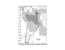
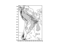
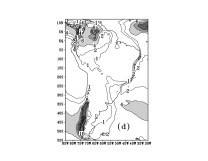
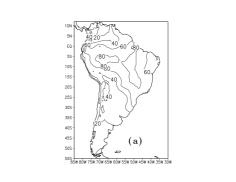
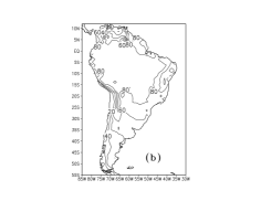
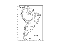
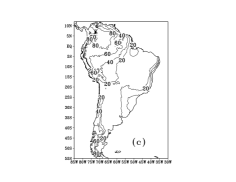
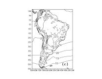
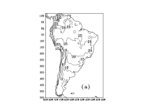
Fig. 1 compares mean precipitation in CRU observations, GPCP data sets, HadAM3P, and (R2 - Eta CCS), (Had - Eta CCS) model simulations for austral summer months from December, to February (DJF) averaged over 4 years from 1980 to 1983. These months are characterized by strong precipitation in most South America east of the Andes. Both CRU and GPCP data sets reproduce precipitation maximum of 8 mm/day associated with the South Atlantic Convergence Zone (SACZ), while both the HadAM3P and (Had - Eta CCS) model runnings are not able to reproduce this maximum. The (R2 - Eta CCS) model running, which is driven by quasi-observational boundary conditions of Reanalysis II, captures this maximum but over smaller region. The precipitation amount area of 4 mm/day seen in the observational data sets is well captured by HadAM3P, while this area is underestimated in the Eta CCS simulations. The model failure in reproducing precipitation patterns associated with SACZ can be related to the deficiencies in their radiation and convection schemes (Tarasova et al., 2006; Figueroa et al., 2006) or/and to the deficiencies in the model humid transport. All models overestimate precipitation amount over high latitudes. As it was discussed by Solman et al. (2007) this can be related to the deficiencies in regional climate modeling of convection processes over mountains. Collection of surface precipitation data over elevated terrains also is not perfect.
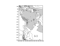
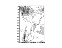
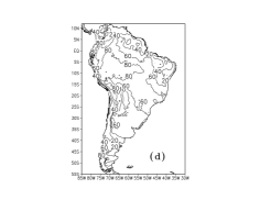
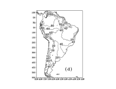
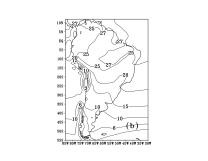
Figure 2 shows the same comparison of the precipitation fields for the austral winter months that is June, July and August (JJA) in South America. Both CRU and GPCP observational data sets demonstrate precipitation maximum over northern part of the continent but its amount is larger in the CRU data set. The largest difference between the model results is also seen over this area where the regional model demonstrates better representation of the precipitation amount than the global model. (Had - Eta CCS) is also better captures the location of the Inter Tropical Convergence Zone (ITCZ) than HadAM3P as compared with the GPCP data set. The dry conditions over the South American continent are reproduced well by all models. All models overestimate observational precipitation amount over southern Chile. The observed bias in the model-simulated mean precipitation fields may be caused by the deficiencis in the Betts-Miller convection scheme used in these simulations or by the deficiencies in the model humid transport.
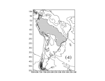
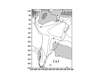
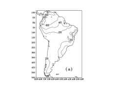
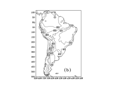
The difference in precipitation amount between the models and observational data sets is related to the difference in precipitation frequency or in precipitation event intencity. The precipitation frequency is defined as number of wet days per month or per season. The wet day is defined in the CRU data set as a day with a daily precipitation amount larger than 0.1 mm. Fig. 3 presents number of wet days during summer (DJF), averaged over the period from 1980 to 1983. The CRU observations and the HadAM3P, (R2 - Eta CCS), (Had - Eta CCS) simulation results are compared. The comparison shows that during summer the model runnings overestimate number of wet days over the South American continent as compared with the CRU observations. The largest overestimation of the area of 80 wet days per season is seen over north part of the continent in the HadAM3P simulations. The (R2 - Eta CCS) model running simulates better the area of 80 days per season than HadAM3M and (Had - Eta CCS). All model runnings overestimate the number of the wet days in the central part of the continent by 20 wet days per season. Fig. 4 shows the comparison of the number of wet days during austral winter (JJA). All models overestimate rainy day frequancy in the northern part of the continent by 20 wet days per season and large overestimation is seen over the Andes.
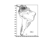
Figs. 5 and 6 present the fields of the near surface air temperature at 2 m in CRU observations, GPCP data sets, HadAM3P, (R2 - Eta CCS), (Had - Eta CCS) model simulations averaged for austral summer (DJF) and winter (JJA) months and 4 years from 1980 to 1983. All models reproduce main patterns of the temperature field over South America but the regional model overestimates temperature magnitude over the northern and central parts of the continent by 2-3 C in summer. This is probably associated with the lack of convective precipitation and hence convective cloudiness in these regions in the Eta model that related to the deficiencies in the model convection parameterization scheme. Temperature values smaller by 0.5-1.0 C were obtained over SACZ in the Eta model simulations with new solar radiation scheme for January 2003 (Tarasova et al., 2006) as compared with its original scheme. For the winter months (JJA) the HadAM3P model shows temperature maximum of 27 C in the north-east part of the continent which is not seen in the CRU data set. The same maximum is captured by the (Had - Eta CCS) model running that is probably related to the impact of the global model boundary conditions.
b. Annual cycle of precipitation for the selected regions and its interannual variations simulated by (Had - Eta CCS), (R2 - Eta CCS) and HadAM3P as compared with the GPCP and CRU data
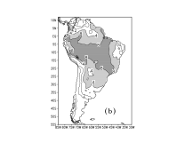
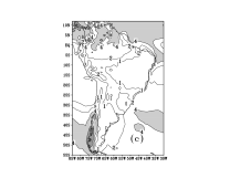
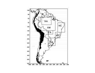
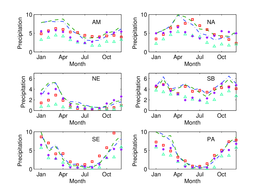
We examined area averaged precipitation annual cycle over the following regions: Amazon (AM), North Amazon (NA), North East Brazil (NE), South Brazil (SB), South East Brazil (SE), Pantanal (PA) shown in Fig. 7. These regions have distinctive climate features that differ from one region to another. For these regions we calculated area averaged monthly mean daily precipitation (mm d-1) averaged over 1980-1983 years for the CRU and GPCP observational dat sets as well as the (R2 - Eta CCS), HadAM3P, (Had - Eta CCS) simulation results. Only land grid points were taken into account in the calculations. Both observational data sets demonstrate similar values of monthly mean precipitation for all regions. According to observational estimates, in the Amazon region the largest values of precipitation are from January to Abril and the smallest values are from June to October. All models capture observed annual cycle of precipitation while the magnitude of precipitation is underestimated, particularly in the summer months. In the North Amazon region there is a distinctive peak of precipitation in Abril which is captured by both HadAM3P and (Had - Eta CCS) models but its magnitude is underestimated. The (R2 - Eta CCS) model captures precipitation maximum in June. In the North East region a peak of precipitation in observational data sets is seen from February to March. All models underestimate precipitation during these months. The monthly mean precipitation in the South Brazil region has 3 maximums, in February, March and November. The shape of annual cycle of precipitation is well captured by the (R2 - Eta CCS) model. Both HadAM3P and (Had - Eta CCS) models capture the precipitation maximum in February but underestimate precipitation values during all months. A strong annual cycle is observed in the South East and Pantanal regions and all models reproduce its shape. In the PA region the magnitude of precipitation is underestimated by all models in the summer months.
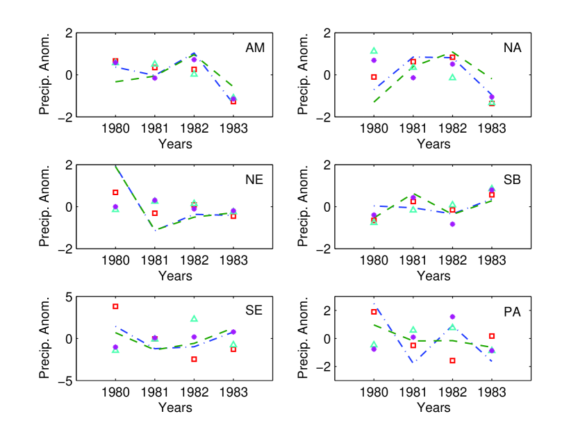
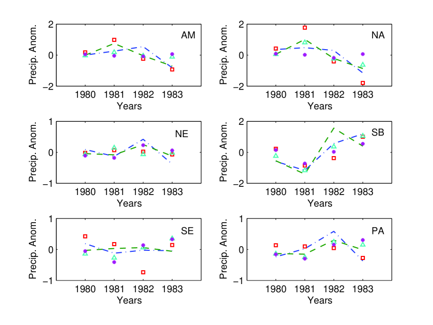
Figs. 9 and 10 show precipitation anomaly averaged over the same regions (Fig. 7) for summer (DJF) and winter (JJA) seasons, respectively. The precipitation anomalies for each year from 1980 to 1983 were calculated as a difference between the season mean precipitation for each year and that averaged over 4 years. In the Pantanal region in summer all models have most difficulties in simulating interannual variation of season mean precipitation. Note, that both observational data sets also have largest differences over this region. The best agreement between the model-simulated and observed precipitation anomalies is seen over the AM and SB regions in summer and over the AM, NE, SB and PA regions in winter.
5. Conclusions
The output fields of precipitation, precipitation frequency, and near surface air temperature simulated by the Eta model over South America were compared with the observational data of the CRU and GPCP projects. The runs of the Eta model were made for the period from January 1979 to December 1983 using boundary conditions derived from the reanalysis and outputs of the HadAM3P model. The model monthly mean results were averaged over four years from January 1980 to December 1983. The comparison of the model-simulated and observed precipitation fields shows that the main patterns of observed fields are reproduced reasonably well by the Eta model driven by both sets of boundary conditions. In both Eta model experiments, the magnitude of precipitation in summer is underestimated in the regions of strong convection activity related to South Atlantic Convection Zone. It can be caused by the deficiencies in the model convection and radiation schemes and in the model humid transport. The magnitude of the underestimation is larger in the experiments used the Eta model driven by HadAM3P than the Eta model driven by reanalysis. This is associated with the lack of precipitation in the HadAM3P model in this region in summer. In winter, the dry conditions over South America are reproduced well by both HadAM3P and the Eta model. The Eta model driven by HadAM3P reproduces better than HadAM3P the magnitude of precipitation in the equatorial part of the South American continent and the position of ITCZ.
The comparison of the model-simulated and observed precipitation frequencies shows that during summer season the observed number of wet days (CRU) is overestimated by HadAM3P. The overestimation is larger over the northern part of the continent. The precipitation frequency is closer to observations in both runs of the Eta model, particularly in the run with the boundary conditions derived from the reanalysis. During winter season, HadAM3P strongly overestimates the precipitation frequency over all continent. The Eta model driven by reanalysis simulates the precipitation frequency closer to observations. The observed patterns of near surface air temperature (CRU) are reproduced well by the HadAM3P and Eta models in both summer and winter seasons. In summer, the Eta model overestimates the magnitude of surface temperature over the central part of the continent due to the lack of convective cloudiness in this region. In winter, both HadAM3P and the Eta model driven by HadAM3P shows the temperature maximum in the northern-eastern part of the continent which is not present in the CRU data. The Eta model captures the observed annual cycle of precipitation in the six selected regions over South America. But the magnitude of precipitation is underestimated in the regions of strong convection activity in summer. On the whole, these results support the conclusion that the Eta model with some improvements can be used for downscaling of the HadAM3P output fields. The deficiencies of the Eta model in tropics and subtropics are probably associated with the deficiencies in the model convection and radiation schemes.
References
Adler RF, Huffman GJ, Chang A, Ferraro R, Xie P, Janowiak J, Rudolf B, Schneider U, Curtis S, Bolvin D, Gruber A, Susskind J, Arkin P (2003) The Version 2 Global Precipitation Climatology Project (GPCP) Monthly Precipitation Analysis (1979-Present). J Hydrometeor 4:1147-1167
Betts AK, and Miller MT (1986) A new convective adjustment scheme. Part II: Single column tests GATE wave, BOMEX, and Arctic air-mass data. Quart J Roy Met Soc 112: 693-703
Black TL (1994) NMC notes: the new NMC mesoscale Eta model: description and forecast examples. Wea Forecasting 9:256-278
Chen FK, Janjic Z, and Mitchel K, (1997) Impact of the atmospheric surface-layer parameterizations in the new land-surface scheme of the NCEP mesoscale Eta model. Bound-Layer Meteor 85: 391-421
Chou M-D, and Suarez MJ (1999) A solar radiation parameterization (CLIRAD-SW) for atmospheric studies. Preprint NASA/Goddard Space Flight Center, Greenbelt, Maryland, 38 pp
Chou M-D, Suarez MJ, Liang X-Z, and Yan M M-H (2001) A thermal infrared radiation parameterization for atmospheric Studies. Preprint NASA/Goddard Space Flight Center, Greenbelt, Maryland, 55 pp
Dickinson RE, Errico RM, Giorgi F, and Bates GT (1989) A regional climate model for the western United States. Clim Change 15:383-422
de Elia R, Caya D, Cote H, Frigon A, Biner S, Giguere M, Paquin D, Harvey R, Plummer D (2007) Evaluation of uncertainties in the CRCM-simulated North American climate. Clim Dyn, in Press
Fels SB, and Schwartzkopf MD (1975) The simplified exchange approximation: A new method for radiative transfer calculations. J Atmos Sci 32:1475-1466
Giorgi F, and Bates GT (1989) The climatological skill of a regional model over complex terrain. Mon Wea Rev 117:2325-2347
Grell GA, Dudhia J, Stauffer DR (1993) A description of the fifth-generation Penn System/NCAR mesoscale model (MM5). NCAR Tech Note NCAR/TN-398+1A, 107 pp
Hong S-Y, Yuang H-M, and Zhao Q (1998) Implementing of prognostic cloud scheme for a regional spectral model. Mon Wea Rev 126:2621-2639
Janjic ZI (1994) The step-mountain eta coordinate model: further development of the convection, viscous sublayer, and turbulence closure schemes. Mon Wea Rev 122:927-945
Kain JS, and Fritsch JM (1993) A one-dimensional entraining detraining plume model and its applications in convective parameterization. J Atmos Sci 23:2784-2802
Kanamitsu M, Ebisuzaki W, Woollen J, Yang S-K, Hnilo JJ, Fiorino M, and Potter GL (2002) NCEP-DOE AMIP-II Reanalysis (R-2). Bull Amer Meteor Soc 83:1631-1643
Kalnay E, Coauthors (1996) The NCEP-NCAR 40-year reanalysis project. Bull Am Meteor Soc 77:437-471
Lacis AA, and Hansen JE (1974) A parameterization for the absorption of solar radiation in the Earth’s atmosphere. J Atmos Sci 31:118-133
Mellor GL, and Yamada T (1974) A hierarchy of turbulence closure models for boundary layers. J Atmos Sci 31:1791-1806.
Mesinger F, Janjic ZI, Nickovic S, Gavrilov D, and Deaven DG (1988) The step-mountain coordinate: model description and performance for cases of Alpine lee cyclogenesis and for a case of Appalachian redevelopment. Mon Wea Rev 116:1493-1518
Mitchell TD, Carter TR, Jones PD, Hulme M, New M (2003) A comprehensive set of high-resolution grids of monthly climate for Europe and the globe: the observed record (1901-2000) and 16 scenarios (2001-2100). J Clim
New MG, Hulm M, Jones PD (1999) Representing twentieth-century space time climate variability. Part I. Development of a 1961-1990 mean monthly terrestrial climatology. J Clim 12:829-856
Pal JS, Giorgi F, Bi X et al (2006) The ICTP RegCM3 and RegCNET: regional climate modeling for the developing World. Bull Am Meteorol Soc (in press)
Pope V, Gallani M, Rowntree P, Stratton R (2000) The impact of new physical parameterizations in the Hadley Centre Climate model. Clim Dyn 16:123-146
Pisnichenko IA, and Tarasova TA (2007) The climate version of the Eta regional forecast model. 1. Evaluation of consistency between the Eta model and HadAM3P global model. http://arxiv.org/abs/0709.2110v2
Roeckner E, Aroe K, Bengtsson L et al (1996) The atmospheric general circulation model ECHAM-4: model description and simulation of present day climate. Technical report, 218, Max-Plank Institute for Meteorology
Seth A, Rauscher SA, Camargo SJ (2007) RegCM3 regional climatologies for South America using reanalysis and ECHAM global model driving fields. Clim Dyn 28:461-480 doi: 10.1007/s00382-006-0191-z
Slingo JM (1987) The development of a cloud prediction model for the ECMWF model. Quart J Royal Met Soc 113:899-927
Solman SA, Nunez MN, Cabre MF (2007) Regional climate change experiments over southern South America. I: present climate. Clim Dyn, in Press
Tarasova TA, and Fomin BA (2000) Solar radiation absorption due to water vapor: Advanced broadband parameterizations. J Appl Meteor 39:1947-1951
Xie P, Janowiak J, Arkin PA, Adler RF, Gruber A, Ferraro RR, Huffman GJ, Curtis S (2003) GPCP Pentad Precipitation Analysis: Am Experimental Dataset Based on Gauge Observations and Satellite Estimates. J Clim, 16:2197-2214
Xie P, Arkin P (1996) Analesis of global monthly precipitation using gauge observation, satellite estimates and numerical model prediction. J Clim 9:840-858
Xu K-M, and Randall DA (1996) A semi empirical cloudiness parameterization for use in climate models. J Atmos Sci 53:3084-3102
Figure captions
Figure 1. DJF mean precipitation (mm d-1) averaged over 1980-1983 years: (a) GPCP, (b) CRU, (c) HadAM3P, (d) Had-Eta CCS, (e) R2-Eta CCS.
Figure 2. JJA mean precipitation (mm d-1) averaged over 1980-1983 years: (a) GPCP, (b) CRU, (c) HadAM3P, (d) Had-Eta CCS, (e) R2-Eta CCS.
Figure 3. Number of wet days during austral summer (DJF) averaged over 1980-1983 years: (a) CRU, (b) HadAM3P, (c) Had-Eta CCS, (d) R2-Eta CCS.
Figure 4. Number of wet days during austral winter (JJA) averaged over 1980-1983 years: (a) CRU, (b) HadAM3P, (c) Had-Eta CCS, (d) R2-Eta CCS.
Figure 5. DJF mean near surface air temperature (∘C) averaged over 1980-1983 years: (a) CRU, (b) HadAM3P, (c) Had-Eta CCS.
Figure 6. JJA mean near surface air temperature (∘C) averaged over 1980-1983 years: (a) CRU, (b) HadAM3P, (c) Had-Eta CCS.
Figure 7. The 6 regions selected for the analysis: Amazon (AM),North Amazon (NA), North East Brazil (NE), South Brazil (SB), South East Brazil (SE), Pantanal (PA).
Figure 8. Annual cycle of monthly mean daily precipitation (mm d-1) averaged over 1980-1983 years and 6 regions (Amazon (AM), North Amazon (NA), North East Brazil (NE), South Brazil (SB), South East Brazil (SE), Pantanal (PA)) from CRU (dashed), GPCP (dot-dashed), R2-Eta CCS (square), HadAM3P (filled circle), Had-Eta CCS (triangle).
Figure 9. DJF mean precipitation anomaly (mm d-1) averaged over 1980-1983 years and 6 regions (Amazon (AM), North Amazon (NA), North East Brazil(NE), South Brazil (SB), South East Brazil(SE), Pantanal (PA)) from CRU (dashed), GPCP (dot-dashed), R2-Eta CCS (square), HadAM3P (filled circle), Had-Eta CCS (triangle).
Figure 10. JJA mean precipitation anomaly (mm d-1) averaged over 1980-1983 years and 6 regions (Amazon (AM), North Amazon (NA), North East Brazil (NE), South Brazil (SB), South East Brazil(SE), Pantanal (PA)) from CRU (dashed), GPCP (dot-dashed), R2-Eta CCS (square), HadAM3P (filled circle), Had-Eta CCS (triangle).