Sites for Gamma-ray Astronomy in Argentina
Abstract
We have searched for possible sites in Argentina for the installation of large air Cherenkov telescope arrays and water Cherenkov systems. At present seven candidates are identified at altitudes from 2500 to 4500 m. The highest sites are located at the NW of the country, in La Puna. Sites at 2500 and 3100 m are located in the West at El Leoncito Observatory, with excellent infrastructure. A description of these candidate sites is presented with emphasis on infrastructure and climatology.
Keywords:
Site search, Site testing, Ground-based gamma-ray astronomy:
95.45.+i, 95.55.Ka, 95.85.Pw1 Introduction
After successful operation of Cherenkov telescopes, like HESS, MAGIC and VERITAS, the scientific community is beginning to seek for sites to locate a new generation of instruments. Not only air Cherenkov but also water Cherenkov detectors are expanding frontiers. HAWC is being constructed in Mexico and would require a counterpart in the Southern Hemisphere. At smaller scale, LAGO has been expanding from Auger, in Argentina, to Bolivia, Mexico, Venezuela and Perú, seeking for high altitude sites to install single water Cherenkov tanks.
For galactic gamma-ray astronomy the observation from a Southern Hemisphere location has obvious advantages as the most important portion of the Galactic Plane is seen from the South, including the Galactic Center. For extragalactic gamma-ray astronomy, a homogeneous distribution of instruments should be spread over the World, especially for monitoring of transient sources, like AGNs, which require a complete time coverage (RA coverage). In the Northern Hemisphere the distribution of air Cherenkov telescopes is such that this could be achieved. The lack of telescopes in South America, however, prevents the correct time coverage for the Southern Hemisphere. For water Cherenkov detectors this problem is attenuated by their large angular acceptance.
Requirements for gamma ray detectors are wide. For water Cherenkov, high altitude and water availability have to be considered. For air Cherenkov, moderate altitudes, atmospheric transparency and low cloud coverage are required. In any case, good infrastructure and local support are desired. In South America moderate and high altitude sites are located in ”La Puna” and its surroundings. This region extends from the NW of Argentina, up to the North of Chile, West of Bolivia and SW of Perú. In this area the cloud cover improves toward the SW so only the North of Chile and NW of Argentina would be available for Cherenkov telescopes. In Chile there are several Observatories with optical, infrared and millimetric telescopes. The ALMA array is being deployed and might extend its aperture by locating a single dish in Argentina mirabel . On the East of La Puna, in Argentina, there are sites being characterized for Extremely Large Telescopes (ELT) by a local group (for ESO). Optical (CASLEO: www.casleo.gov.ar), Radio (IAR: www.iar.unlp.edu.ar) and cosmic-ray (Auger: www.auger.org) observatories are operating in the country, with an important academic community.
In the last two years we have been searching for sites in Argentina that fulfill conditions for both water and air Cherenkov detectors. Here we report on such searches.
2 Explored regions
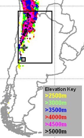
To seek for a flat land of 1 km2 at more than 2500 meters above sea level (masl) with clear skies in Argentina, the Central and NW regions of the country have to be considered. In Figure 1 a search for 1 km2 sites at different altitudes is shown fegan . So far we have searched two subregions, one at high altitudes on the North and another at moderate altitudes on the South (see Figure 1, right). The northern region is part of La Puna, a land at more than 3500 masl. In Argentina this region is located to the East of the Andes mountains, on the provinces of Jujuy, West of Salta, and North of Catamarca. The region at moderate altitudes extends to the South of La Puna, on the West of the provinces of La Rioja, San Juan and Mendoza. In the following sections we report on two searched regions, the northern portion of La Puna and the National Reserve of “El Leoncito”, in San Juan.

3 High altitude sites: La Puna
A map of the northern explored region is shown in Figure 2. La Puna is climatologically classified as a highland climate. It has low temperatures, poor vegetation, and a low annual precipitation with a dry winter. It extends along the leeward slopes of the Andes where winds are dominated by the Pacific high pressure system (subsidence). Advection from the Pacific causes a predominant wind from the West which is the main control of climate in the whole Puna sch . A roughly similar West-East regime exists for rainfall, humidity and cloudiness.
As an example, we can cite meteorological data from two stations. One is near Susques, at 3675 masl, and the second is La Casualidad (25:03 S, 68:13 W), located at 4092 masl, 300 km SW of Susques. From Susques we have data from 1972 to 1990 (Dirección de Hidráulica de Jujuy), only on precipitation and temperature: average annual total rainfall is 184 mm (mainly in summer) and average temperature is 7.6 Celsius. From La Casualidad we have ten years of data from 1963 to 1972 servicio : annual averages are: wind: 26% calm, 55% from West (28 km/h), 13% from NW (22 km/h) and 5% from SW (24 km/h); Sky coverage: 22 days; humidity 33%; temp.: 3.9 Celsius; low temp.: - 4.1 Celsius; frost: 267 days; total rainfall: 37 mm in 6.3 days; snow: 2.8 days.
By analyzing historical climate data, Schwerdtfeger sch shows that cloudiness is another variable that seems to show roughly the same West-East behaviour in La Puna. Dedicated studies have been done by the IATE group in their search for ELT recabarren and by Erasmus erasmus for the ALMA project using satellite images. Results from these analyses are all coherent with each other. The result on sky cover shown by Schwerdtfeger indicates that the isoneph of 20% is right to the East of the whole region studied by both Erasmus and IATE. All of them indicate that cloudiness decreases toward the West. For the selected sites in Figure 2 we note that the sky cover conditions are similar in average ( 85% of clear nights), except for Mina Aguilar (5) which is more into the cloudy skies. However, if a seasonal analysis is done, the northern sites, (2) and (3), have larger variations than the other two locations in the South, (1) and (4), being better in winter and worse in summer.
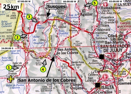
This region has two major cities with international airports and daily flights to Buenos Aires. San Salvador de Jujuy (pop. 250,000) and Salta (pop. 500,000). They host their national universities: U. de Jujuy (10,000 students) and U. de Salta (20,000 students). Two towns are identified in this area, Susques and S.A. de los Cobres.
Susques (23:23:12 S, 66:21:47 W) is a small town (pop. 2000) at 3675 masl. It takes 2.5-3 hours ride from Jujuy city (202 km) driving on a very nice paved road that connects to the West with Antofagasta (Chile), through the border point “Paso de Jama” (4400 masl). There are two good hotels in Susques both located on the National Route 52 at 3700 masl: “Hotel Unquillar” (www.elunquillar.com.ar) and “Hotel Pastos Chicos” (www.pastoschicos.com.ar), with an overall allocation of 60 beds in 20 rooms at u$s30 (single rate). Satellite TV and regular and cell phone services are available.
San Antonio de los Cobres (SAC) (24:13:30 S, 66:19:10 W) (pop. 3000) is at 3775 masl. From Salta city it takes 2.5 hours (164 km) driving on the National Route 51, which is 75% of the way a paved road. Route 51 continues as gravel road to the West to connect with Chile at “Paso Sico” (4092 masl). There is one good hotel in town, “Hotel de las Nubes”, which has approximately 25 beds in 10 rooms at a similar rate of Susques. Satellite TV and regular and cell phone services are available.
3.1 Identified candidate sites
Tolar Grande: Astronomers from IATE are characterizing this site for the location of ELT (ESO). Their chosen point is in the Macón mountain range, 25km East of Tolar Grande (24:38:49 S, 67:20:14 W) at 4600 masl. There are several experiments being carried out there to characterize the sky. This led us to consider Tolar Grande as a reference site, where flat lands at 4000 masl can be found. It takes 3.5-4 hours to get there from SAC and there is a nice lodging house at low rates.
Salar de Pocitos: 80 km SW of SAC we have identified a candidate site nearby the small neighborhood of Salar de Pocitos, where no significant infrastructure is available except electricity, water and phone connection. It takes 2-2.5 hours drive from SAC (140 km) on a very nice gravel road to get there. The site is a very extended plain at 3750 masl (slope 0.01), limiting with a mountain range to the West and a salt land to the East, 5 km West of route 27 (24:26:40 S, 67:06:10 W). Ground is compact and vegetation is very poor. There is a railroad crossing the field. The salt land on the East should not contribute with aerosols as wind is mainly from the West.
El Porvenir: Few km South from the intersection of routes 52 and 70, we identified a possible site at 3950 masl (23:38:30 S, 66:46:30 W). From there, it takes 40 minutes drive (65 km) on the paved route 52 to get Susques, where a base of operation could be located. There are 5 km of flat plain from route 70 before reaching the mountain range on the West. There is also a salt land to the East which should not contribute to the air aerosol content as wind is mainly from the West.
El Taire: This is a site specially identified for water Cherenkov systems (23:23:41 S, 66:31:27 W). It is at 4150 masl closeby route 52, 20 km West of Susques. There is a stream of spring water and perforation is a general practice to get water from underground.
Alto Tocomar: This is the highest plain we have identified (24:12:00 S; 66:30:30 W). It is 25 km West of SAC at 4500 masl, closeby route 51, with nearby summits of more than 5000 masl and several km2 of flat land. There is a railroad crossing the site and few spring water points have been localized at the western border.
Mina Aguilar: Another excellent site for water Cherenkov systems (23:09:03 S, 65:42:55 W). It is at 3900 masl, nearby a small town with all supplies needed for operations, including stores and hospital. A site at 5100 masl is easy to access by vehicle in 20 min. drive.
4 Moderate altitude Sites

El Leoncito Astronomical Observatory (CASLEO: Complejo AStronómico el LEOncito) (31:48:00 S, 69:17:30 W) is an astronomical facility located at 2600 masl in the province of San Juan, with offices and laboratories in the city of San Juan. In Figure 3 we show the road map of the area. The Observatory is placed inside a reservation area of 416 has. dedicated to astronomy, which is part of the National Park “El Leoncito”, a 70,000 has. natural reserve. There are two major cities with daily connection to Buenos Aires, San Juan (pop. 450,000), and Mendoza (pop. 900,000). These two cities are the host of their national universities: U. de San Juan (20,000 students), and U. de Cuyo (38,000 students). There is a small town, Barreal (pop. 2500), 40 km NW (30 min. drive) of the Observatory where basic supplies are available. Regular transportation to the mountain is organized by the Observatory staff several times per week. It takes 3.5 hours to get from San Juan to the Observatory (250 km) on a good paved road, through Calingasta and Barreal. One alternative for international travelers is to flight to Santiago (Chile), connect to Mendoza and take a rented car to reach the site through Uspallata. It also takes 3.5 hours to get from Mendoza city to the Observatory (230 km), mostly on paved road.
The most distinctive feature of a site in this area is the Observatory infrastructure. After more than 20 years of operation the site has everything needed for operating and maintaining any running instrument on the mountain. A 13.2 KV power line, an emergency generator, internet (25 Mbps) and regular and cell phone services are available. There are on the mountain mechanical and electronics workshops, a liquid nitrogen plant and a 2.15 m mirror coating chamber. The lodging facilities include bedrooms with private toilets for 45 people and a dining room for the same number. More than ten people from the staff are permanently at the site for maintenance, cleaning, cooking and to attend visitors.
The Observatory has its own meteorological station (www.casleo.gov.ar/weather/leonci_weather.htm). Monthly values for the last ten years are: mean temperature: 5.5 C (July) and 17.5 C (January); maximum temperature: 20.3 C (June) and 30.5 C (January); rel. hum.: 27-43 % along the year; rainfall: 11-18 mm (December-March) and 2-7 mm (April-November); wind speed: 4.5-8.4 km/hr, mainly from SW (55 %) and from SE (30 %); maximum wind speed: 62-88 km/hr along the year; hail: 1-2 days/yr; frost: none; lightning: 6-8 days/yr; maximum snowfall: ¡30 cm.
Analyzing more than 20 years of operations the Observatory has 270 observing nights per year (74 %), from which 100 nights are photometric (more than 6 hr of perfect sky conditions). Sky brightness has been measured in magnitudes per square arcsecond: U = 22.1, B = 23.3 and V = 22.7. For comparison, these values are similar to those at Cerro Tololo Inter-American Observatory (from CTIO), Chile: U = 22.0, B = 22.7 and V = 21.8.
In an attempt to connect both the northern and southern studied regions, the IATE group analyzed 1.5 years of GOES images (1998-1999) of both El Leoncito and La Puna. The uncertainties of this study are unknown but good enough to say that between site candidates on the North and South there is a difference of 10% in sky coverage, being the northern sites better and characterizing El Leoncito with 75% of clear nights.
4.1 Identified candidate sites at El Leoncito
Tontal: To the West of the Tontal range there is a plain of at least 510 km2 at 3000 to 3500 masl. We have pointed to a specific site at 3130 masl (31:48:12 S; 69:10:31 W), located 15 km to the East of the Observatory. Once in the site, accessibility is very good.
Naranjo: To the North of the Observatory on the West of El Naranjo range there is a site of similar characteristics of Tontal but with slightly smaller slope. The marked location is at 2590 masl (31:43:52 S; 69:16:20 W). This site was the former SKA candidate site. It is very easy to access from the Observatory by a 20 min. drive (10 km). Ground is compact assuring accessibility.
5 Final Comments
We have searched for candidate sites for ground-based gamma-ray astronomy in two regions of Argentina: a northern region, in La Puna, and a southern one, nearby the El Leoncito Astronomical Observatory. In La Puna we have found five candidate sites at altitudes from 3750 to 4500 masl, being the ones on the SW better suited for air Cherenkov detection, as there are 85 % of clear nights. Sites near the town of Susques (El Taire and El Porvenir) have very good accessibility and reasonable infrastructure. The highest site (Alto Tocomar) is 25 km from San Antonio de los Cobres, where a base for operations can be mounted. The lowest site in the area, Salar de Pocitos, is the best candidate for air Cherenkov although infrastructure is rather poor. The northeastern site, Mina Aguilar, has all needed for water Cherenkov systems but is too far into cloudy skies for air Cherenkov detectors. Earthquake risk is moderate in La Puna. At El Leoncito we identified two sites at 2590 and 3130 masl. El Leoncito Observatory has been operational for 20 years and has excellent infrastructure including lodging, power, internet, phone, food, mechanical/electronics workshops, regular transportation, etc. It has 75 % of clear nights. Earthquake risk is of some importance but similar to other astronomical observatories.
Acknowledgments: We are grateful to Olga Penalba for information on climatology and the local SKA group for site information. The work at IATE is being supported by ESO. The following authors are members of CONICET: ACR, GER, XB, AE, BG, DGL, HL, HM and PR.
References
- (1) I.F. Mirabel, personal communication.
- (2) S. Fegan, in Towards a future ground-based gamma ray observatory. October 20, 2005, Malibu, California, USA.
- (3) W. Schwerdtfeger, “Climates of central and South America,” in World Survey of Climatology, Vol. 12, Elsevier. Amsterdam, Oxford, New York, 1976.
- (4) SMN (Servicio Meteorológico Nacional, Argentina), in N. Estadística Climatológica 35, Serie B, FAA, 1961-70.
- (5) P. Recabarren, et al., Ast. and Space Sci. 290, 409 (2004).
- (6) D.A Erasmus, “An analysis of cloud cover and water vapor for the ALMA project,” in www.eso.org/gen-fac/pubs/astclim/espas/radioseeing/, 2002.