Comparative Study of Cities as Complex Networks
Abstract
Degree distributions of graph representations for compact urban patterns are scale-dependent. Therefore, the degree statistics alone does not give us the enough information to reach a qualified conclusion on the structure of urban spatial networks. We investigate the statistics of far-away neighbors and propose the new method for automatic structural classification of cities.
PACS codes: 89.75.Fb, 89.75.-k, 89.90.+n
Keywords: Complex networks, city space syntax
1 Introduction
Comparative studies of cities adopt classifications, such as cultural or geographical criteria, and then apply analytical tools to characterize the existing groups in morphological terms [1, 2, 3]. However, in recent space syntax investigations devoted to the comparative classification of urban textures, the predefined categories have been avoided and groups have been interpreted as a result of the analysis [4, 5].
Methods for automatic classification or grouping, broadly termed hierarchical clustering have been discussed in [5]. The general idea behind the hierarchical clustering is that elements of any set have similarities and differences that can be mapped as distances in a multi-dimensional space in which each characteristic (variable) represents an axis. Then, clusters are created by grouping isolated elements or subgroups or, alternatively, splitting the set into smaller groups, according to the distance between them.
In the present paper, we propose the new automatic classification method based on the structural statistics of so called justified graphs used in urban space syntax theory [14].
Most real world networks can be considered complex by virtue of features that do not occur in simple networks. The encoding of cities into non-planar dual graphs (Sec. 2) reveals their complex structure, [17].
If cities were perfect grids in which all lines have the same length and number of junctions, they would be described by regular graphs exhibiting a high level of similarity no matter which part of urban texture is examined. This would create a highly accessible system that provides multiple routes between any pair of locations. It was believed that pure grid systems are easy to navigate due to this high accessibility and to the existence of multiple paths between any pair of locations [23, 22]. Although, the urban grid minimizes descriptions as long as possible in the ideal grid all routes are equally probable; morphology of the perfect grid does not differentiate main spaces and movement tend to be dispersed everywhere [17]. Alternatively, if cities were purely hierarchical systems (like trees), they would clearly have a main space (a hub, a single route between many pairs of locations) that connects all branches and controls movement between them. This would create a highly segregated, sprawl like system that would cause a tough social consequence, [17].
However, real cities are neither trees nor perfect grids, but a combination of these structures that emerge from the social and constructive processes [14]. They maintain enough differentiation to establish a clear hierarchy [24] resulting from a process of negotiation between the public processes (like trade and exchanges) and the residential process preserving their traditional structure. The emergent urban network is usually of a very complex structure which is therefore naturally subjected to the complex network theory analysis.
In order to illustrate the applications of complex network theory methods to the structural investigations of dual graphs representing urban environments, we have studied five different compact urban patterns.
Two of them are situated on islands: Manhattan (with an almost regular grid-like city plan) and the network of Venice canals (imprinting the joined effect of natural, political, and economical factors acting on the network during many centuries). In the old city center of Venice that stretches across 122 small islands in the marshy Venetian Lagoon along the Adriatic Sea in northeast Italy, the canals serve the function of roads, and every form of transport is on water or on foot.
We have also considered two organic cities founded shortly after the Crusades and developed within the medieval fortresses: Rothenburg ob der Tauber, the medieval Bavarian city preserving its original structure from the 13th century, and the downtown of Bielefeld (Altstadt Bielefeld), an economic and cultural center of Eastern Westphalia.
To supplement the study of urban canal networks, we have investigated that one in the city of Amsterdam. Although it is not actually isolated from the national canal network, it is binding to the delta of the Amstel river, forming a dense canal web exhibiting a high degree of radial symmetry.
Table 1: Some features of studied dual city graphs
| Urban pattern | Intelligibility | |||
|---|---|---|---|---|
| Rothenburg ob d.T. | 50 | 115 | 5 | 0.85 |
| Bielefeld (downtown) | 50 | 142 | 6 | 0.68 |
| Amsterdam (canals) | 57 | 200 | 7 | 0.91 |
| Venice (canals) | 96 | 196 | 5 | 0.97 |
| Manhattan | 355 | 3543 | 5 | 0.51 |
The scarcity of physical space is among the most important factors determining the structure of compact urban patterns. Some characteristics of studied dual city graphs are given in Tab.1. There, is the number of open spaces (streets/canals and places) in the urban pattern (the number of nodes in the dual graphs), is the number of junctions (the number of edges in the dual graphs); the graph diameter, is the maximal depth (i.e., the graph-theoretical distance) between two vertices in a dual graph; the intelligibility parameter estimates navigability of the city, suitability for the passage through it [14].
In Sec. 2, we discuss the possible graph representations for the urban spatial networks and explain our choice of the dual graph representation. In Sec. 3, we consider the statistics of justified graphs studied in space syntax theory and introduce the urban structure matrix describing the statistics of far-away neighbors. Then, we introduce the structural distance between cities in Sec. 4 and conclude in the last section.
2 Graphs and space syntax of urban environments
Urban space is of rather large scale to be seen from a single viewpoint; maps provide us with its representations by means of abstract symbols facilitating our perceiving and understanding of a city. The middle scale and small scale maps are usually based on Euclidean geometry providing spatial objects with precise coordinates along their edges and outlines.
There is a long tradition of research articulating urban environment form using graph-theoretic principles originating from the paper of Leonard Euler (see [6]). Graphs have long been regarded as the basic structures for representing forms where topological relations are firmly embedded within Euclidean space. The widespread use of graph theoretic analysis in geographic science had been reviewed in [7] establishing it as central to spatial analysis of urban environments. In [8], the basic graph theory methods had been applied to the measurements of transportation networks.
Network analysis has long been a basic function of geographic information systems (GIS) for a variety of applications, in which computational modelling of an urban network is based on a graph view in which the intersections of linear features are regarded as nodes, and connections between pairs of nodes are represented as edges [9]. Similarly, urban forms are usually represented as the patterns of identifiable urban elements such as locations or areas (forming nodes in a graph) whose relationships to one another are often associated with linear transport routes such as streets within cities [12]. Such planar graph representations define locations or points in Euclidean plane as nodes or vertices , , and the edges linking them together as , in which The value of a link can either be binary, with the value as , and otherwise, or be equal to actual physical distance between nodes, , or to some weight quantifying a certain characteristic property of the link. We shall call a planar graph representing the Euclidean space embedding of an urban network as its primary graph. Once a spatial system has been identified and represented by a graph in this way, it can be subjected to the graph theoretic analysis.
A spatial network of a city is a network of the spatial elements of urban environments. They are derived from maps of open spaces (streets, places, and roundabouts). Open spaces may be broken down into components; most simply, these might be street segments, which can be linked into a network via their intersections and analyzed as a networks of movement choices. The study of spatial configuration is instrumental in predicting human behavior, for instance, pedestrian movements in urban environments [14]. A set of theories and techniques for the analysis of spatial configurations is called space syntax [18]. Space syntax is established on a quite sophisticated speculation that the evolution of built form can be explained in analogy to the way biological forms unravel [13]. It has been developed as a method for analyzing space in an urban environment capturing its quality as being comprehendible and easily navigable [14]. Although, in its initial form, space syntax was focused mainly on patterns of pedestrian movement in cities, later the various space syntax measures of urban configuration had been found to be correlated with the different aspects of social life, [19].
Decomposition of a space map into a complete set of intersecting axial lines, the fewest and longest lines of sight that pass through every open space comprising any system, produces an axial map or an overlapping convex map respectively. Axial lines and convex spaces may be treated as the spatial elements (nodes of a morphological graph), while either the junctions of axial lines or the overlaps of convex spaces may be considered as the edges linking spatial elements into a single graph unveiling the topological relationships between all open elements of the urban space. In what follows, we shall call this morphological representation of urban network as a dual graph.
The transition to a dual graph is a topologically non-trivial transformation of a planar primary graph into a non-planar one which encapsulates the hierarchy and structure of the urban area and also corresponds to perception of space that people experience when travelling along routes through the environment.
In Fig. 1, we have presented the glossary establishing a correspondence between several typical elements of urban environments and the certain subgraphs of dual graphs. The dual transformation replaces the 1D open segments (streets) by the zero-dimensional nodes, Fig. 1(1).
| 1. | 2. | ||
|---|---|---|---|
| 3. | 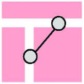 |
4. |  |
| 5. | 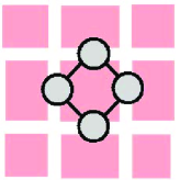 |
6. | 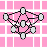 |
The sprawl like developments consisting of a number of blind passes branching off a main route are changed to the star subgraphs having a hub and a number of client nodes, Fig. 1(2). Junctions and crossroads are replaced with edges connecting the corresponding nodes of the dual graph, Fig.1(3). Places and roundabouts are considered as the independent topological objects and acquire the individual IDs being nodes in the dual graph Fig. 1(4). Cycles are converted into cycles of the same lengthes Fig. 1(5). A regular grid pattern is shown in Fig. 1(6). Its dual graph representation is called a complete bipartite graph, where the set of vertices can be divided into two disjoint subsets such that no edge has both end-points in the same subset, and every line joining the two subsets is present, [20]. These sets can be naturally interpreted as those of the vertical and horizontal edges in the primary graphs (streets and avenues). In bipartite graphs, all closed paths are of even length, [21].
It is the dual graph transformation which allows to separate the effects of order and of structure while analyzing a transport network on the morphological ground. It converts the repeating geometrical elements expressing the order in the urban developments into the twins nodes, the pairs of nodes such that any other is adjacent either to them both or to neither of them. Examples of twins nodes can be found in Fig. 1(2,4,5,6).
3 Justified graphs and urban structure matrices: statistics of far away neighbors
In space syntax theory, graph-based models of space are used in order to investigate the influence of the shape and configuration of environments on human spatial behavior and experience. A number of configurational measures have been introduced in so far in quantitative representations of relationships between spaces of urban areas and buildings. Although similar parameters quantifying connectivity and centrality of nodes in a graph have been independently invented and extensively studied during the last century in a varied range of disciplines including computer science, biology, economics, and sociology, the syntactic measures are by no means just the new names for the well known quantities. In space syntax, the spaces are understood as voids between buildings restraining traffic.
The main focus of the space syntax study is on the relative proximity (or accessibility) between different locations which involves calculating graph-theoretical distances between nodes of the dual graphs and associating these distances with densities and intensities of human activity which occur at different open spaces and along the links which connect them [10, 11, 12].
Space adjacency is a basic rule to form axial maps: two axial lines intersected are regarded as adjacency. The dual graph is a labelled graph, in which labels are assigned to its nodes representing open spaces of the system. Two spaces, and , are held to be adjacent in the dual graph when it is possible to move freely from one space to another, without passing through any intervening. These two nodes, each node representing an individual vista space, are connected by an edge of the dual graph. A syntactic step is defined as the direct connection between neighboring individual open spaces or between overlapping isovists, .
Although graphs are usually shown diagrammatically, this is only reasonable when the number of vertices and edges is small enough. Graphs can also be represented in the form of matrices. The major advantage of matrix representation is that the calculation of paths and cycles can easily be performed using well known operations on matrices. The adjacency matrix of the dual graph is defined as follows:
| (1) |
Let us note that rows and columns of corresponding to the twins nodes are identical. Depth is a topological distance between nodes in the dual graph . Two open spaces, and , are said to be at depth if the least number of syntactic steps needed to reach one node from the other is , [15]. In particular, if two axial lines intersect on the axial map, then the depth between them is equal to one. Given a connected dual graph, we can compute the depths between all pairs of its nodes.
In order to visualize the overall depth of spatial layout seen from one of its points, the justified graph is used in the space syntax analysis, [16]. Justified graph is a graph restructured so that a specific space is placed at the bottom, the root space. All spaces one syntactic step away from root space are put on the first level above, all spaces two steps away on the second level, etc, [15]. A tree-like justified graph has most of the nodes many steps (levels) away from the bottom node. In such a system the mean depth is high and described as deep. A bush-like justified graph has most of the nodes near the bottom and the system is described as shallow.
We begin with the analysis of a dual graph representing a piece of urban texture with a selection of a street (a node in the dual graph) as a starting point. This street will be intersected by a number, , of other streets, which are labelled depth . These streets will then be intersected by streets, which are labelled depth , etc. As a consequence of the analysis, each street in the map is numbered according to how many changes of direction (or elementary navigation actions) separate it from the starting street.
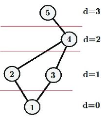
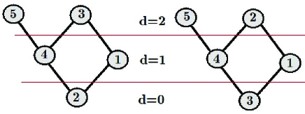
In space syntax theory, the centrality level of a node is analyzed by means of a justified graph restructured so that the node is placed at the bottom being a root of the graph, and all spaces (nodes) one syntactic step away from the root space are put on the first level above, all spaces two spaces away on the second level, etc. In Fig. 2, we have presented a small graph of five nodes, with the node being a root.
If a root node belongs to a tree-like component of the dual graph, it obviously has most of the nodes many steps away. Such a ”deep” space with a high mean depth is segregated from most of other spaces in the city probably belonging to a city fringe. Being chosen as roots, the nodes of high centrality produce shallow justified graphs with most of nodes near the bottom.
Given a root node , the justified graph can be specified by the vector , in which is the number of nodes being at a depth away from the root node . For example, the specification vector for the justified graph given in Fig. 2 is where we put the index indicating that the graph has been drawn with respect to the root node . Other four justified graphs which can be constructed from that one shown in Fig. 2 by placing other nodes at the bottom are specified by the vectors Let us note that the specification vectors correspondent to the twins nodes and are identical as well as the relevant justified graphs (see Fig. 3).
It is worth to mention that the first component of the specification vector for the node is nothing but its connectivity, . It is also clear that specification vectors generalize the notion of connectivity accounting for all far away neighbors a given node has at a distance away from it.
We introduce the automatic classification method for urban textures based on the statistics over all specification vectors for a given dual graph.
Given a dual graph , we introduce a rectangular, integer structure matrix , which entries, , equal to the numbers of specification vectors, with -component . In terms of graph theory, is nothing else but the number of nodes in which have precisely neighbors at a distance away from them. By definition the matrix is independent of a particular layout of street IDs being inherent to the given . The similar matrix has been recently proposed in [25] in order to portrait large complex networks.
Despite its strong influence on various properties of complex networks, the degree statistics is but one of many important characteristics of a graph. Complex networks may possess similar degree distributions yet differ widely in other properties. The urban structure matrix contains more detailed information on the structure of the graph than the probability degree distribution alone. The degree distribution statistics (the statistics of immediate neighbors) is encoded in the first row of the urban structure matrix (at ),
| (2) |
Other rows of describe the statistics of far away neighbors a node has at a distance ,
| (3) |
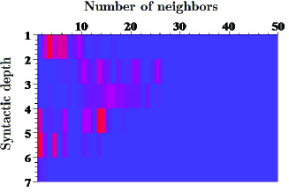
In Fig. 4, the matrix plot of for the downtown of Bielefeld is sketched out. It is interesting to note that the distributions of far-away neighbors () are far from being the monotonous decreasing functions of the number of neighbors, in contrast to the distribution of immediate neighbors, .
The matrix plot (4) unveils a complicated, scale dependent structure of the urban texture. The urban structure matrix can be used in order to define a structural distance between the different urban textures.
4 Cumulative structure matrix and structural distance between cities
The statistics of far away neighbors can be presented in the form of cumulative distribution functions quantifying the probabilities that the number of neighbors a node has at a distance is greater than or equal to . Being monotonous functions of , cumulative distributions reduce the noise in the distribution tails, however the adjacent points on their plots are not statistically independent.
The cumulative distributions are encoded in rows of the cumulative structure matrix,
| (4) |
The plots of cumulative distributions of far-away neighbors in the dual city graphs shown in Fig. 5-6.
4.1 Portraits of cities as complex networks
Usual networks constitute graphs in which most nodes are neighbors of one another, and the number of far-away neighbors grows up fast with the distance apart from a node. The portraits of German medieval cities are the examples (Fig. 5).
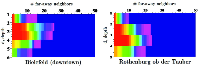
It is seen from the red profile on Fig. 5 that most of streets in these organic cities are just by three syntactic steps away from each other. In contrast to them, the cumulative distributions of far-away neighbors in the dual city graphs displayed in Fig. 6 show that while for the street grid in Manhattan and for the canal network of Venice most nodes can still be reached in at most three syntactic steps, there are also a noticeable fraction of relatively segregated nodes few steps deeper than the others.
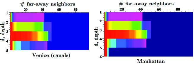
The structure of cumulative distributions shown in Fig. 6 evidences in favor of that the correspondent dual graphs have high representation of cliques, and subgraphs that miss just a few edges of being cliques. In complex network theory, this phenomenon is referred to as a small world. Small-world networks are characterized by a high clustering coefficient having connections between almost any two nodes within them. Hubs - nodes in the network with a high number of connections serving as the common connections mediating the short path lengths between other edge are commonly associated with small-world networks, [27].
The small world phenomenon indicated on the city portraits in Fig. 6 acquires an elegant explanation in the framework of space syntax theory.
In [26], [14], it has been suggested that the spatial structure of organic cities is shaped by the public processes ordered in such a way as to maximize the presence of people in the central areas. In such a context, the compact structure of German medieval burghs (Fig. 5) uncovers its historical functional pertinence.
The tendency to shorten syntactic distances in urban space networks induced by the public processes is complemented in the ”small world” cities (like those portrayed in Fig. 6) with the residential process which shapes relations between inhabitants and strangers preserving the original residential culture against unsanctioned invasion of privacy. While most of streets and canals characterized with an excellent accessibility promotes commercial activities and intensifies cultural exchanges, the certain districts of such cities stipulate the alternative tendency having the residential areas relatively segregated from the rest of the urban fabric.
4.2 Structural distance between cities
A simple metric comparing two urban patterns represented by their dual graphs, and , may be defined, using their cumulative structure matrix, and .
In order to measure dissimilarities between distributions, the Wasserstein distance is widely used in probabilistic contexts [28]. When applied to sample distributions the Wasserstein distance leads to the -based tests of goodness of fit. Given two sets of probabilities, and , with finite second order moment, the Wasserstein distance between them is defined as the lowest -distance between random variables and defined in any probability space, with these distribution laws:
| (5) |
in which is the mean. It is worth to mention that the Wasserstein distance is not the only possible measure of dissimilarities between distributions which can be implemented in the comparative analysis of urban structures. For example, in [25] the Kolmogorov-Smirnov test [30] has been used instead of the Wasserstein distance (5).
Motivated by the Wasserstein distance [28], we introduce the following statistic between the corresponding pairs of rows and , :
| (6) |
where and are the sizes of the dual graphs and respectively.
It is clear that while comparing the dual graphs of different sizes, we use the ”upper left corners” of their cumulative structure matrices suggesting that near neighbors located just a few steps away have greater impact on network properties. For instance, only the shallow neighbors have been taken into account in the traditional space syntax analysis of urban textures. Therefore, it seems reasonable to assign weights to the shallow neighbors statistics while estimating their contributions into similarity /dissimilarity of cities. An appropriate set of weights for distances has been proposed in [25],
| (7) |
Then, the structural distance between two dual graphs, and , is calculated by:
| (8) |
It equals zero if the distributions of far-away neighbors over the first shells of two dual graphs, and , are identical. Alternatively, the structural distance approaches one as these distributions are orthogonal.
Table 2: The table of structural distances between the dual graphs of compact urban patterns.
| Bielefeld | Rothenburg | Amsterdam | Venice | Manhattan | |
|---|---|---|---|---|---|
| Bielefeld | 0 | 0.043 | 0.321 | 0.139 | 0.396 |
| Rothenburg | 0.043 | 0 | 0.127 | 0.324 | 0.412 |
| Amsterdam | 0.139 | 0.127 | 0 | 0.316 | 0.450 |
| Venice | 0.321 | 0.324 | 0.316 | 0 | 0.244 |
| Manhattan | 0.396 | 0.412 | 0.450 | 0.244 | 0 |
In Tab. 2, we have presented the structural distances between the dual graphs of five compact urban patterns calculated in accordance to (8).
It is important to note that the structural distances given in the Tab. 2 have been calculated independently for each pair of urban textures with reference to their sizes and distributions of far away neighbors. It is obvious that they do not belong to the same space and therefore cannot be immediately compared.
5 Discussion and Conclusion
The degree distribution has become an important concept in complex network theory describing the topology of complex networks. It originates from the study of random graphs by Erdös and Rényi, [31]. The importance of the implemented street identification principle is worth mentioning for the investigations on the degree statistics of dual city graphs. The comparative investigations of different street patterns performed in [32, 33] implementing the ICN principle reveal scale-free degree distributions for the vertices of dual graphs. However, in [34] it has been reported that under the street-name approach the dual graphs exhibit small-world character, but scale-free degree statistics can hardly be recognized. The results on the probability degree statistics for the dual graphs of compact urban patterns analyzed in accordance with the above described street identification principle are compatible with that reported in [34]. In general, compact city patterns do not provide us with sufficient data to conclude on the universality of degree statistics.
The probability degree distributions for the dual graph representations of the five compact urban patterns mentioned in Tab. 1 has been studied by us in [35]. To give an example, we display in Fig. 7 the log-log plot is sketched of the number of streets in Manhattan versus the number of their junctions , where
| (9) |
These numbers are displayed by points. The solid line is associated to cumulative degree distribution, where
| (10) |
is the probability that the degree is greater than or equal to . The presentation of degree data by the cumulative degree distribution has an advantage over the degree distribution (9), since it reduces the noise in the distribution tail, [29].
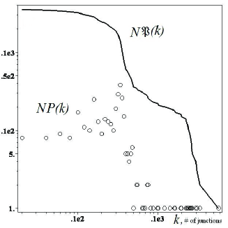
It is remarkable that the observed profiles are broad indicating that a street in a compact city can cross the different number of other streets, in contrast while in a regular grid. At the same time, the distributions usually have a clearly noticeable maximum corresponding to the most probable number of junctions an average street has in the city. The long right tail of the distribution which could decay even faster then a power law is due to just a few ”broadways,” embankments, and belt roads crossing many more streets than an average street in the city, [35]. It has been suggested in [17] that irregular shapes and faster decays in the tails of degree statistics indicate that the connectivity distributions is scale-dependent. As a possible reason for the non-universal behavior is that in the mapping and descriptive procedures, inadequate choices to determine the boundary of the maps or flaws in the aggregation process can damage the representation of very long lines. Being scale-sensitive in general, the degree statistics of dual city graphs can nevertheless be approximately universal within a particular range of scales.
The scale-dependence of degree distributions indicate that the degree statistics alone does not give us the enough information to reach a qualified conclusion on the structure of urban spatial networks. Thus, the statistics of far-away neighbors would be targeted to reduce the gap providing us with a new method for automatic structural classification of cities.
6 Acknowledgment
The work has been supported by the Volkswagen Foundation (Germany) in the framework of the project: ”Network formation rules, random set graphs and generalized epidemic processes” (Contract no Az.: I/82 418). The authors acknowledge the multiple fruitful discussions with the participants of the workshop Madeira Math Encounters XXXIII, August 2007, CCM - CENTRO DE CIÊNCIAS MATEMÁTICAS, Funchal, Madeira (Portugal).
References
- [1] M. Major, ”Are American cities different? if so, how do they differ” in Proc. International Space Syntax Symposium, M. Major, L. Amorim, F. Dufaux (eds), University College London, London, vol. 3, 09.1-09.14 (1997).
- [2] K. Karimi, ”The spatial logic of organic cities in Iran and in the United Kingdom” in Proc. International Space Syntax Symposium, M. Major, L. Amorim, F. Dufaux (eds), University College London, London, vol. 1, 05.1-05.17 (1997).
- [3] B. Hillier, Urban Design International 7, 153-179 (2002).
- [4] V. Medeiros, F. Holanda, ”Urbis Brasiliae: investigating topological and geometrical features in Brazilian cities”, in A. Van Nes (ed.), Proc. International Space Syntax Symposium, Delft, Faculty of Architecture, Section of Urban Renewal and Management, pp. 331-339 (2005).
- [5] L. Figueiredo, L. Amorim, ”Continuity lines in the axial system”, in A Van Nes (ed.)Proc. International Space Syntax Symposium, Delft, Faculty of Architecture, Section of Urban Renewal and Management, pp. 161-174 (2005).
- [6] N. Biggs, E. Lloyd, and R. Wilson, Graph Theory, 1736-1936. Oxford University Press (1986).
- [7] P. Haggett, R. Chorley (eds.), Socio-Economic Models in Geography, London, Methuen (1967); P. Haggett, R. Chorley, Network Analysis in Geography, Edward Arnold, London (1969).
- [8] K.J. Kansky, Structure of Transportation Networks: Relationships Between Network Geometry and Regional Characteristics, Research Paper 84, Department of Geography, University of Chicago , Chicago, IL (1963).
- [9] H.J. Miller, S.L. Shaw, Geographic Information Systems for Transportation: Principles and Applications, Oxford Univ. Press, Oxford (2001).
- [10] W. G. Hansen, Journal of the American Institute of Planners 25, 73-76 (1959) .
- [11] A. G. Wilson, Entropy in Urban and Regional Modelling, Pion Press, London (1970).
- [12] M. Batty, A New Theory of Space Syntax, UCL Centre For Advanced Spatial Analysis Publications, CASA Working Paper 75 (2004).
- [13] B. Hillier, A. Leaman, P. Stansall, M. Bedford, Environment and Planning B 3, 147-185 (1976).
- [14] B. Hillier, Space is the machine. A configurational theory of architecture, Cambridge University Press (1996).
- [15] Björn Klarqvist, ”A Space Syntax Glossary”, Nordisk Arkitekturforskning 2 (1993).
- [16] B. Hillier, J. Hanson, The Social Logic of Space (1993, reprint, paperback edition ed.). Cambridge: Cambridge University Press (1984).
- [17] L. Figueiredo, L. Amorim, Decoding the urban grid: or why cities are neither trees nor perfect grids, 6th International Space Syntax Symposium, 12-15 Jun 2007, Istanbul, Turkey.
- [18] B. Jiang, ”A space syntax approach to spatial cognition in urban environments”, Position paper for NSF-funded research workshop Cognitive Models of Dynamic Phenomena and Their Representations, October 29 - 31, 1998, University of Pittsburgh, Pittsburgh, PA (1998).
- [19] C. Ratti, Environment and Planning B: Planning and Design, vol. 31, pp. 487 - 499 (2004).
- [20] M.J.T. Kruger, On node and axial grid maps: distance measures and related topics. Other. Bartlett School of Architecture and Planning, UCL, London, UK (1989).
- [21] S. Skiena, Implementing Discrete Mathematics: Combinatorics and Graph Theory with Mathematica, Reading, MA: Addison-Wesley (1990).
- [22] M. Rosvall, A. Trusina, P. Minnhagen, K. Sneppen, Phys. Rev. Lett. 94, 028701 (2005).
- [23] M. Rosvall, P. Minnhagen, K. Sneppen, Phys. Rev. E 71, 066111 (2005).
- [24] J. Hanson, Ekistics 56, pp. 334-335 (1989).
- [25] J. P. Bagrow, E. M. Bollt, J. D. Skufca, D. ben-Avraham, Portraits of Complex Networks, cond-mat/0703470 (March, 2007).
- [26] B. Hillier, ”The art of place and the science of space”, World Architecture 11/2005 (185), Beijing, Special Issue on Space Syntax pp. 24-34 (in Chinese), pp. 96-102 (in English) (2005).
- [27] M. Buchanan, Nexus: Small Worlds and the Groundbreaking Theory of Networks. Norton, W. W. and Co., Inc. ISBN 0-393-32442-7 (2003).
- [28] S.T. Rachev, Probability Metrics and the Stability of Stochastic Models], Wiley (1991).
- [29] M.E.J. Newman, SIAM Review 45, 167-256 (2003).
- [30] W.J. Conover, Practical Nonparametric Statistics, Wiley (1998).
- [31] P. Erdos, A. Renyi, Publ. Math. (Debrecen) 6, 290 (1959).
- [32] A. Cardillo, S. Scellato, V. Latora, and S. Porta, Phys. Rev. E 73, 066107 (2006).
- [33] S. Porta, P. Crucitti, and V. Latora, Physica A 369, 853 (2006)
- [34] B. Jiang, C. Claramunt, Environ. Plan. B: Plan. Des. 31, 151 (2004).
- [35] D. Volchenkov, Ph. Blanchard, Phys. Rev. E, 75, 026104 (2007).