A review of wildland fire spread modelling, 1990-present
3: Mathematical analogues and simulation models
Abstract
In recent years, advances in computational power and spatial data analysis (GIS, remote sensing, etc) have led to an increase in attempts to model the spread and behvaiour of wildland fires across the landscape. This series of review papers endeavours to critically and comprehensively review all types of surface fire spread models developed since 1990. This paper reviews models of a simulation or mathematical analogue nature. Most simulation models are implementations of existing empirical or quasi-empirical models and their primary function is to convert these generally one dimensional models to two dimensions and then propagate a fire perimeter across a modelled landscape. Mathematical analogue models are those that are based on some mathematical conceit (rather than a physical representation of fire spread) that coincidentally simulates the spread of fire. Other papers in the series review models of an physical or quasi-physical nature and empirical or quasi-empirical nature. Many models are extensions or refinements of models developed before 1990. Where this is the case, these models are also discussed but much less comprehensively.
Ensis111A CSIRO/Scion Joint Venture Bushfire Research 222current address: Department of Theoretical Physics,
Research School of Physical Sciences and Engineering
The Australian National University, Canberra 0200, Australia.
PO Box E4008, Kingston, ACT 2604, Australia
email: Andrew.Sullivan@ensisjv.com or als105@rsphysse.anu.edu.au
phone: +61 2 6125 1693, fax: +61 2 6125 4676
version 3.0
1 Introduction
1.1 History
The ultimate aim of any prediction system is to enable an end user to carry out useful predictions. A useful prediction is one that helps the user achieve a particular aim. In the field of wildland fire behaviour, that aim is primarily to stop the spread of the fire or to at least reduce its impact on life and property. The earliest efforts at wildland fire behaviour prediction concentrated on predicting the likely danger posed by a particular fire or set of conditions prior to the outbreak of a fire. These fire danger systems were used to set the level of preparedness of suppression resources or to aid in the identification of the onset of bad fire weather for the purpose of calling total bans on intentionally lit fires.
In addition to a subjective index of fire danger, many of early fire danger systems also provided a prediction of the likely spread of a fire, as a prediction of the rate of forward spread of the fire, the rate of perimeter increase or rate of area increase. In many cases, these predictions were used by users to plot the likely spread of the fire on a map, thereby putting the prediction in context with geographic features or resource locations, and constituted the first form of fire spread simulation.
Because much of the development of the early wildland fire behaviour models was carried out by those organisations intended to use the systems, the level of sophistication of the model tended to match the level of sophistication of the technology used to implement it. Thus, the early fire spread models provided only a single dimension prediction (generally the forward rate of spread of the headfire) which could be easily plotted on a map and extrapolated over time. While modern wildland fire spread modelling has expanded to include physical approaches (Sullivan, 2007a, ), all modern operational fire spread models have continued this empirical approach in the form of one-dimensional spread models (Sullivan, 2007b, ). Much of the development of technology for implementing the models in a simulation environment has concentrated on methods for converting the one-dimensional linear model of fire spread to that of two-dimensional planar models of fire spread.
In parallel with approaches to implement existing empirical models of fire spread have been efforts to approach the simulation of fire spread across the landscape from a holistic perspective. This has resulted in the use of methods other than those directly related to the observation, measurement and modelling of fire behaviour. These methods are mathematical in nature and provide an analogue of fire behaviour. Many of these approaches have also paralleled the development of the computer as a computational device to undertake the calculations required to implement the mathematical concepts.
An increase in the capabilities of remote sensing, geographical information systems and computing power during the 1990s resulted in a revival in the interest of fire behaviour modelling as applied to the prediction of spread across the landscape.
1.2 Background
This series of review papers endeavours to comprehensively and critically review the extensive range of modelling work that has been conducted in recent years. The range of methods that have been undertaken over the years represents a continuous spectrum of possible modelling (Karplus,, 1977), ranging from the purely physical (those that are based on fundamental understanding of the physics and chemistry involved in the behaviour of a wildland fire) through to the purely empirical (those that have been based on phenomenological description or statistical regression of fire behaviour). In between is a continuous meld of approaches from one end of the spectrum or the other. Weber, (1991) in his comprehensive review of physical wildland fire modelling proposed a system by which models were described as physical, empirical or statistical, depending on whether they account for different modes of heat transfer, make no distinction between different heat transfer modes, or involve no physics at all. Pastor et al., (2003) proposed descriptions of theoretical, empirical and semi-empirical, again depending on whether the model was based on purely physical understanding, of a statistical nature with no physical understanding, or a combination of both. Grishin, (1997) divided models into two classes, deterministic or stochastic-statistical. However, these schemes are rather limited given the combination of possible approaches and, given that describing a model as semi-empirical or semi-physical is a ‘glass half-full or half-empty’ subjective issue, a more comprehensive and complete convection was required.
Thus, this review series is divided into three broad categories: Physical and quasi-physical models; Empirical and quasi-empirical models; and Simulation and Mathematical analogous models. In this context, a physical model is one that attempts to represent both the physics and chemistry of fire spread; a quasi-physical model attempts to represent only the physics. An empirical model is one that contains no physical basis at all (generally only statistical in nature), a quasi-empirical model is one that uses some form of physical framework upon which to base the statistical modelling chosen. Empirical models are further subdivided into field-based and laboratory-based. Simulation models are those that implement the preceding types of models in a simulation rather than modelling context. Mathematical analogous models are those that utilise a mathematical precept rather than a physical one for the modelling of the spread of wildland fire.
Since 1990, there has been rapid development in the field of spatial data analysis, e.g. geographic information systems and remote sensing. As a result, I have limited this review to works published since 1990. However, as much of the work that will be discussed derives or continues from work carried out prior to 1990, such work will be included much less comprehensively in order to provide context.
1.3 Previous reviews
Many of the reviews that have been published in recent years have been for audiences other than wildland fire researchers and conducted by people without an established background in the field. Indeed, many of the reviews read like purchase notes by people shopping around for the best fire spread model to implement in their part of the world for their particular purpose. Recent reviews (e.g. Perry, (1998); Pastor et al., (2003); etc), while endeavouring to be comprehensive, have offered only superficial and cursory inspections of the models presented. Morvan et al., (2004) takes a different line by analysing a much broader spectrum of models in some detail and concludes that no single approach is going to be suitable for all uses.
While the recent reviews provide an overview of the models and approaches that have been undertaken around the world, mention must be made of significant reviews published much earlier that discussed the processes in wildland fire propagation themselves. Foremost is the work of Williams, (1982), which comprehensively covers the phenomenology of both wildland and urban fire, the physics and chemistry of combustion, and is recommended reading for the beginner. The earlier work of Emmons, (1963, 1966) and Lee, (1972) provides a sound background on the advances made during the post-war boom era. Grishin, (1997) provides an extensive review of the work conducted in Russia in the 1970s, 80s and 90s.
The first paper in this series discussed those models based upon the fundamental principles of the physics and chemistry of wildland fire behaviour. The second paper in the series discussed those models based directly upon only statistical analysis of fire behaviour observations or models that utilise some form of physical framework upon which the statistical analysis of observations have been based. Particular distinction was made between observations of the behaviour of fires in the strictly controlled and artificial conditions of the laboratory and those observed in the field under more naturally occurring conditions.
This paper, the final in the series, focuses upon models concerned only with the simulation of fire spread over the landscape and models that utilise mathematical conceits analogous to fire spread but which have no real-world connection to fire. The former generally utilise a pre-existing fire spread model (which can be physical, quasi-physical, quasi-empirical or empirical) and implements it in such a way as to simulate the spread of fire across a landscape. As such, it is generally based upon a geographic information system (GIS) of some description to represent the landscape and uses a propagation algorithm to spread the fire perimeter across it. The latter models are for the most part based upon accepted mathematical functions or concepts that have been applied to wildland fire spread but are not derived from any understanding of wildland fire behaviour. Rather, these models utilise apparent similarities between wildland fire behaviour and the behaviour of these concepts within certain limited contexts. Because of this, these mathematical concepts could equally be applied to other fields of endeavour and, for the most part have been, to greater or lesser success.
Unlike the preceding entries in this series, this paper is segmented by the approaches taken by the various authors, not by the authors or their organisations, given the broad range of authors that in some instances have taken similar approaches.
2 Fire Spread Simulations
The ultimate aim of any fire spread simulation development is to produce a product that is practical, easy to implement and provides timely information on the progress of fire spread for wildland fire authorities. With the advent of cheap personal computing and the increased use of geographic information systems, the late 1980s and early 1990s saw a flourishing of methods to predict the spread of fires across the landscape (Beer, 1990a, ). As the generally accepted methods of predicting the behaviour of wildland fires at that time were (and still are) one-dimensional models derived from empirical studies (Sullivan, 2007a, ), it was necessary to develop a method of converting the single dimension forward spread model into one that could spread the entire perimeter in two dimensions across a landscape. This involves two distinct processes: firstly, representing the fire in a manner suitable for simulation, and secondly, propagating that perimeter in a manner suitable for the perimeter’s representation.
Two approaches for the representation of the fire have been implemented in a number of softwares. The first treats the fire as a group of mainly contiguous independent cells that grows in number, described in the literature as a raster implementation. The second treats the fire perimeter as a closed curve of linked points, described in the literature as a vector implementation.
The propagation of the fire is then carried using some form of expansion algorithm. There are two main methods used. The first expands the perimeter based on a direct-contact or near-neighbour proximity spread basis. The second is based upon Huygens’ wavelet principle in which each point on the perimeter becomes the source of the interval of fire spread. While the method of propagation and method of fire representation are often tied (for example, Hyuygens’ wavelet principle is most commonly used in conjuction with a vector representation of the fire perimeter, there is no reason why this should be so and methods of representation and propagation can be mixed.
2.1 Huygens wavelet principle
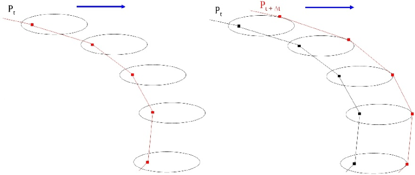
Huygen’s wavelet principle, originally proposed for the propagation of light waves, was first proposed in the context of fire perimeter propagation by Anderson et al., (1982). In this case, each point on a fire perimeter is considered a theoretical source of a new fire, the characteristics of which are based upon the given fire spread model and the prevailing conditions at the location of the origin of the new fire. The new fires around the perimeter are assumed to ignite simultaneously, to not interact and to spread for a given time, . During this period, each new fire attains a certain size and shape, and the outer surface of all the individual fires becomes the new fire perimeter for that time.
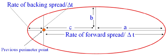
Anderson et al., (1982) used an ellipse to define the shape of the new fires with the long axis aligned in the direction of the wind. Ellipse shapes have been used to described fire spread in a number of fuels (Peet,, 1965; McArthur,, 1966; Van Wagner,, 1969) and, although many alternative and more complex shapes have been proposed (e.g. double ellipse, lemniscate and tear drops (Richards,, 1995), the ellipse shape has been found to adequately described the propagation of wildland fires allowed to burn unhindered for considerable time (Anderson et al.,, 1982; Alexander,, 1985). The geometry of the ellipse template is determined by the rate of forward spread as predicted by the chosen fire spread model and a suitable length-to-breadth ratio (L:B) to give the dimensions of the ellipse (Fig. 1). McArthur, (1966) proposed ratios for fires burning in grass fuels in winds up to 50 km h-1. Alexander, (1985) did the same for fires in conifer forests also up to a wind speed of 50 km h-1.
Figure 2 illustrates the application of Huygens’ principle to the propagation of a fire perimeter utilising the ellipse template. A section of perimeter defined by a series of linked nodes that act as the source of a series of new fires. The geometry of the ellipse used for each new fire is determined by the prevailing conditions, the chosen fire spread model and length-breadth ratio model, and the given period of propagation . In the simple case of homogeneous conditions, all ellipses are the same and the propagation is uniform in the direction of the wind. The boundary of the new ellipses forms the new perimeter at .
Richards, (1990, 1995) produced analytical solutions for this modelling approach, for a variety of template shapes, in the form of a pair of differential equations. A computer algorithm Richards and Bryce, (1996) that utilises these equations was developed and was subsequently incorporated into fire simulation packages, including FARSITE (USA) (Finney,, 1994, 1998) and Prometheus (Canada) (CWFGM Steering Committee,, 2004). An alternative method that utilises the elliptical geometry only is that of Knight and Coleman, (1993) which is used in SiroFire (Australia) (Beer, 1990a, ; Coleman and Sullivan,, 1996). This method provides solutions to the two main problems with the closed curve expansion approach using Huygens’ wavelet principle, namely rotations in the perimeter, in which a section of perimeter turns itself inside-out, and enclosures, in which unburnt fuel is enclosed by two sections of the same perimeter (termed a ‘bear hug’). A similar method was proposed by Wallace, (1993).
FARSITE is widely used in the US by federal and state land management agencies for predicting fire spread across the landscape. It is based upon the BEHAVE (Andrews,, 1986) fire behaviour prediction systems, which itself is based upon the spread model of Rothermel, (1972). It includes models for fuel moisture content (Nelson,, 2000), spotting (Albini,, 1979), post-front fuel consumption (Albini and Reinhardt,, 1995; Albini et al.,, 1995), crown-fire initiation (Van Wagner,, 1977) and crown-fire spread (Rothermel,, 1991). It is PC-based in MS-Windows and utilises the ARCView GIS system for describing the spatial fuel data and topography.
SiroFire was developed for operational use in Australia and utilises McArthur’s fire spread models for grass (McArthur,, 1966) and forest (McArthur,, 1967) as well as the recommended replacement grassland model (Cheney et al.,, 1998) and versions of Rothermel’s models configured for Australian grass and forest litter fuel, however while it was never used operationally it did find use as a training tool for volunteer bushfire firefighters. It uses a proprietary geographic format intended to reduce computation time with data derived from a number of GIS platforms. It was PC-based using DOS protected mode although would run under MS-Windows. It has now been subsumed into a risk management model, Phoenix, being developed by the University of Melbourne
The Canadian Wildland Fire Growth Model, Prometheus, is based on the Canadian Fire Behaviour Prediction (FBP) System (Forestry Canada Fire Danger Group,, 1992) and utilises the wavelet propagation algorithms of Richards, (1995); Richards and Bryce, (1996) to simulate the spread of wildland fire across landscapes. It was initially developed by the Alberta Sustainable Resource Development, Forest Protection Division for the Canadian Forest Service, but is now a national interagency endeavour across Canada endorsed by the Canadian Interagency Forest Fire Centre. It is Windows-based, utilises maps and geographic data exported from the Esri GIS platform ARC and is intended for use as a realtime operational management tool. As with FARSITE and SiroFire, Prometheus allows the user to enter and edit fuel and meteorological data and carry out simulations of fire spread.
The symmetric nature of the template ellipse in conjunction with the application of Huygens’ wavelet principle neatly provides the flank and rear spread of a fire. By relating the flank and rear spread through the ellipse geometry, the single forward rate of spread of the fire is all that is needed to simulate the spread of the entire perimeter. French et al., (1990) found that in homogeneous fuels and weather conditions, the Huygens’ wavelet principle with template ellipse shape suitably modelled fire spread, with only small distortion of the fire shape. However, such a method cannot adequately handle conditions and fuels that are heterogeneous and errors introduced through changes in the conditions during the period as well as distortions in the fire perimeter due to artifacts in the Huygens’ wavelet method.
Changes in conditions during the propagation period cause the predicted perimeter to over- or under-predict the spread of the perimeter because those changes are not reflected in the predicted perimeter. Reducing can reduce the impact of such changes and a flexible approach to the setting of has been used with great success (Finney,, 1998).
2.2 Raster-based simulation
In a raster-based simulation, the fire is represented by a raster grid of cells whose state is unburnt, burning or burnt. This method is computationally less intensive than that of the closed curve (vector) approach, and is much more suited to heterogenous fuel and weather conditions. However, because fuel information needs to be stored for each and every cell in the landscape, there is a trade-off between the resolution at which the data is stored and the amount of data that needs to be stored (and thus memory requirements and access times, etc)333In vector data, fuel is stored as polygons represented by a series of data points representing the vertices of the outline of the fuel and the fuel attributes for the whole polygon. Very large areas can be stored in this fashion but with overhead in processing to determine if a point is inside the polygon..
The method of expanding the fire in this fashion is similar to that of cellular automata, in which the fire propagation is considered to be a simple set of rules defining the interaction of neighbouring cells in a lattice. I will differentiate fire propagation simulations that utilise a pre-existing fire spread model to determine the rate of fire expansion from those that are true cellular automata. The former are described here as raster- or grid-based simulations and the latter are dealt with in the following section on mathematical analogues.
Kourtz and O’Regan, (1971) were the first to apply computer techniques to the modelling of fire spread across a landscape. Initially simulating the smouldering spread of small fires ( ha) using a grid of 50 50 square cells each of 1 ft2 in no wind and no slope, this model was extended using a combination of Canadian and US (Rothermel,, 1972) fire behaviour models (Kourtz et al.,, 1977) and the output was in the form of text-based graphical representation of predicted spread. King, (1971) developed a model of rate-of-area increase of aerial prescribed burns (intended for use on a hand-held calculator) based on an idealised model of the growth of a single spot fire. Fransden and Andrews, (1979) utilised a hexagonal lattice to represent heterogeneous fuel beds and a least-time-to-ignition heat balance model to simulate fire spread across it. Green, (1983); Green et al., (1983) generalised the approach of Kourtz and O’Regan and investigated the effect of discontinuous, heterogeneous fuel in square lattices on fire shape utilising both a heat balance and a flame contact spread models and found that while fire shapes are less regular than in continuous fuels, the fires tended to become more elliptical in shape as the fire progressed, regardless of the template shape used.
Green et al., (1990) produced a landscape modelling system called IGNITE that utilised the fire spread mechanics of Green, (1983). This system is a raster-based fire spread model that uses fire spread models of McArthur, (1966, 1967) as retro-engineered by Noble et al., (1980) and an elliptical ignition template to predict the rate of forward spread in the form of “time to ignition” for each cell around a burning cell. IGNITE very easily deals with heterogenous fuels and allows the simulation of fire suppression actions through changes in the combustion characteristics of the fuel layers.
Kalabokidis et al., (1991) and Vasconcelos and Guertin, (1992) introduced similar methods to spatially resolve Rothermel’s spread model in BEHAVE by linking it to raster-based GIS platforms. Kalabokidis et al., (1991) developed a simulation technique that derived a ‘friction’ layer within the GIS for six base spread rates for which the friction value increased as spread rate decreased. This was combined with six wind speed classes to produce a map of potential fire extent contours and fireline intensity strata across a range of slope and aspect classes. Vasconcelos and Guertin, (1992) developed a similar simulation package called FIREMAP that continued the earlier work of Vasconcelos et al., (1990). FIREMAP stored topographic, fuel and weather information as rasterised layers within the GIS. It is assumed that the resolution of the rasters are such that all attributes within each cell are uniform. Fire characteristics such as rate of spread, intensity, direction of maximum spread, flame length, are calculated for each cell and each weather condition to produce a database of output maps of fire behaviour. Simulation is then undertaken by calculating each cell’s ‘friction’ or time taken for a fire front to consume a cell. Ball and Guertin, (1992) extended the work of Vasconcelos by improving the method used to implement the cell to cell spread by adjusting the ROS for flank and rear spread based upon BEHAVE’s cosine relation with head fire ROS. The authors found the resulting predicted fire shapes to be unnaturally angular and attribute this to the poor relation for flank spread given by BEHAVE, the regular lattice shape of the raster, and the fact that spread angles are limited, concluding that the raster structure cannot properly represent ’the continuous nature of the actual fire’.
Karafyllidis and Thanailakis, (1997) developed a raster-based simulation also based on Rothermel, (1972) for hypothetical landscapes. The state of each raster cell is the ratio of the area burned of the cell to the total area of the cell. The passage of the fire front is determined by the sum of the states of each cell’s neighbours at each time step until the cell is completely burnt. This approach requires, as input parameter for each cell, the rate of spread of a fire in that cell based on the fuel alone. Berjak and Hearne, (2002) improved the model by incorporating the effects of slope and wind on the scalar field of cell rate of spread using the slope effect model of Cheney, (1981) and an empirical flame angle/wind speed function. This model was then applied to spatially heterogeneous Savanna fuels of South Africa and found to be in good agreement with observed fire spread.
FireStation (Lopes et al.,, 1998, 2002) and PYROCART (Perry et al.,, 1999) both implement Rothermel’s fire spread model in a raster-based GIS platform. FireStation utilises both single and double-ellipse fire shape templates, depending on wind speed, to dictate the spread across cells. The 3-dimensional wind field across the landscape is based on local point observations extrapolated using either a linear conservation of mass approach, or a full 3-dimensional solution of the Navier-Stokes equations. Slope is treated as an ‘equivalent’ wind. PYROCART utilises the fire shape model of Green et al., (1990) which is a function of wind speed. It was validated against a small wildfire and its predictive accuracy (a measure of performance based on the percentage of cells predicted to be burnt compared to those that were unburnt or not predicted to burn) estimated to be 80%.
Guariso and Baracani, (2002) extend the standard 2-dimensional approach to modelling the spread of a surface fire by implementing two levels of raster-based models, one to represent surface fuel and its combustion and another to represent, once a critical threshold value has been reached, the forest canopy and its combustion. They utilise Rothermel’s fire spread model with fuel models modified and validated for Mediterranean fuel complexes. To improve its capabilities as an operational tool, fire fighting resources are tracked on screen using Global Positional System (GPS). Trunfio, (2004) implemented Rothermel’s model using a hexagonal cell shape and found that the model did not produce the spurious symmetries found with square-shaped lattices.
2.3 Other propagation methods
There are alternatives to the raster cell or vector ellipse template propagation methods described above, although these are less widespread in their use. Coupled fire-atmosphere models that incorporate a pre-existing fire spread model (such as given by Rothermel or McArthur) are, at their most basic, a form of propagation algorithm. The coupled fire-atmosphere model of Clark et al., 1996a ; Clark et al., 1996b ; Clark et al., (2004) represents a considerable effort to link a sophisticated 3-dimensional high-resolution, non-hydrostatic mesoscale meteorological model to a fire spread model. In this particular case, the mesoscale meteorological model was originally developed for modelling atmospheric flows over complex terrain, solving the Navier-Stokes and continuity equations and includes terrain following coordinates, variable grid size, two-way interactive nesting, cloud (rain and ice) physics, and solar heating (Coen,, 2005). It was originally linked to the empirical model of forest fire spread of McArthur, (1967) (Clark et al.,, 1998) but was later revised to incorporate the spread model of Rothermel instead (Coen and Clark,, 2000).
The atmosphere model is coupled to the fire spread model through the sensible (convection and conduction effects) and latent heat fluxes approximated from the fireline intensity (obtained via the ROS) predicted by the model for a given fuel specified in the model. Fuel is modelled on a raster grid of size 30 m (Coen,, 2005). Fuel moisture is allowed to vary diurnally following a very simple sinusoid function based around an average daily value with a fixed lag time behind clock time (Coen,, 2005). Assumptions are made about the amount of moisture evaporated prior to combustion. Fuel consumption is modelled using the BURNUP algorithm of Albini and Reinhardt, (1995). Effects of radiation, convection and turbulent mixing occurring on unresolved scales (i.e. 30 m) are ‘treated crudely’ without any further discussion.
The coarse nature of the rasterised fuel layer meant that a simple cell fire spread propagation technique was too reliant on the cell resolution. A fire perimeter propagation technique that is a unique mix of the raster- and the vector-based techniques was developed. Each cell in the fuel layer is allowed to burn at an independent rate, dependent upon the predicted wind speed at a height of 5 m, the predicted rate of spread and the fuel consumption rate. Four tracers aligned with the coordinate system, each with the appropriate ROS in the appropriate directions (headfire ROS is defined as that parallel to the wind direction) are used to track the spread of fire across a fuel cell. The coordinates of the tracers define a quadrilateral that occupies a fuel cell which is allowed to spread across the fuel cell. The tracers move across a fuel cell until they reach a cell boundary. If the adjacent cell is unburnt, it is ignited and a fresh set of tracers commenced for the boundaries of that cell. Meanwhile, once the tracers reach a cell boundary, they can then only move in the orthogonal direction. In this way, the quadrilateral can progress across the cell. The boundaries of all the quadrilaterals then make up the fire perimeter. The size of the quadrilateral then allows an estimate of the amount of fuel that has been consumed since the cell ignited. The fireline propagation method allows for internal fire perimeters, although it only allows one fireline per fuel cell.
The interaction between the heat output of the burning fuel and the 3-dimensional wind field results in complex wind patterns, which can include horizontal and vertical vortices. Clark et al., 1996a ; Clark et al., 1996b ; Jenkins et al., (2001) explored these in producing fireline phenomena such as parabolic headfire shape, and convective and dynamic fingering. However, as wind speed increases ( 5 m s-1 at 15 m above ground), Clark et al., 1996b found that the coupling weakens and the wind flows through the fire.
The real utility of the coupled fire-atmosphere model, however, is the prediction of wind direction around the fire perimeter, used to drive the spread of the fire. This, in effect, replaces Huygens’ wavelet approach with a much more physically direct method. However, the use of Rothermel’s fire spread model for spread in directions other than in the direction of the prevailing wind is questionable and results in odd deformations in the fire perimeter when terrain or fuel are not uniform (Clark et al.,, 2004).
Several other workers have taken the same approach as Clark in linking a mesoscale meteorological model to a fire model. Gurer and Georgopoulos, (1998) coupled an off-the-shelf mesoscale meteorological model (the Regional Atmospheric Modeling System (RAMS) (Pielke et al.,, 1992) with Rothermel’s model of fire spread to predict gas and particulate fall out from forest fires for the purpose of safety and health. The Rothermel model is used to obtain burning area and heat for input into RAMS. Submodels are used for prediction of the emission components (CO2, CH4, etc, polycyclic aromatic hydrocarbons, etc). Simulation of the fire perimeter propagation is not undertaken. Speer et al., (2001) used a numerical weather prediction model to predict the speed and direction of the wind for input into a simple empirical model of fire spread through heathland fuel to predict the rate of forward spread (not to simulate the spread) of two wildfires in Sydney 1994.
Plourde et al., (1997) extend the application of Huygens’s wavelet propagation principle as utilised by Knight and Coleman (1993). However, rather than relying on the template ellipse as the format for the next interval propagation, the authors utilise an innovative closed contour method based on a complex Fourier series function. Rather than considering the perimeter as a series of linked points that are individually propagated, the perimeter is considered as a closed continuous curve that is propagated in its entirety. A parametric description of the perimeter is derived in which the x and y coordinates of each point are encoded as a real and imaginary pair. However, as with Knight and Coleman, (1993), a sufficiently fine time step is critical to precision and anomalies such as rotations and overlaps must be identified and removed. Plourde et al.,, ’s propagation model appears to handle heterogeneous fuel but the timestep is given as 0.05 s, resulting in very fine scale spread but with the trade-off of heavy computational requirements.
Viegas, (2002) proposed an unorthodox propagation mechanism in which the fire perimeter is assumed to be a continuous entity that will endeavor to rotate to align itself with a slope to an angle of approximately 60 degrees across the slope. Based on observation of laboratory and field experiments of line fires lit at angles to the slope, Viegas constructs a fire perimeter propagation algorithm in which he redefines the flank spread of a fire burning in a cross-slope wind as a rotation of the front.
In perhaps a sign of the times, Seron et al., (2005) takes the physical model of Asensio and Ferragut, (2002) and simulates it using the techniques and approaches developed for computer generated imagery (CGI). A strictly non-realtime method is used to solve the fire spread model utilising satellite imagery and the terrain (using flow analysis techniques), interpolated using kriging, to determine fuel and non-burnables such water bodies and rivers, etc. All attributes are non-dimensionalised. Wind is calculated as a vector for each cell derived from the convection form of the physical fire model (Asensio et al.,, 2005). This vector is then added to the terrain gradient vector. 256 x 256 cells are simulated, resulting in 131589 equations that need to be solved for each timestep, which is 0.0001 s.
3 Mathematical Analogues
In the broader non-wildland-fire-specific literature there is a considerable number of works published involving wildland fire spread that are not based on wildland fire behaviour. For the most part, these works implement mathematical functions that appear analogous to the spread of fires and thus are described as wildland fire spread models, while in some cases wildland fire spread is used simply as a metaphor for some behaviour. These mathematical functions include cellular automata and self-organised criticality, reaction-diffusion equations, percolation, neural networks and others. This section briefly discusses some of the fire spread-related applications of these functions.
3.1 Cellular automata and self-organised criticality
Cellular automata (CA) are a formal mathematical idealisation of physical systems in which space and time are discretised, and physical quantities take on a finite set of values (Wolfram,, 1983). CA were first introduced by Ulam and von Neumann in the late 1940s and have been known by a range of names, including cellular spaces, finite state machines, tessellation automata, homogenous structures, and cellular structures. CA can be described as discrete space/time logical universes, each obeying their own local physics (Langton,, 1990). Each cell of space is in one of a finite number of states at any one time. Generally CAs are implemented as a lattice (i.e. 2D) but can be of any dimension. A CA is specified in terms of the rules that define how the state changes from one time step to the next and the rules are generally specified as functions of the states of neighbours of each cell in the previous time step. Neighbours can be defined as those cells that share boundaries, vertices or even more further removed444In a 2D lattice, the cells sharing boundaries form the von Neumann neighbourhood (4 neighbours), cells sharing boundaries and vertices form the Moore neighbourhood (8 neighbours) (Albinet et al.,, 1986). The key attribute of a CA is that the rules that govern the state of any one cell are simple and based primarily upon the states of its neighbours, which can result in surprisingly complex behaviour, even with a limited number of possible states (Gardner,, 1970) and can be capable of Universal Computation (Wolfram,, 1986).
Due to the inherent spatial capacity with interrelations with neighbouring cells, CA have been used to model a number of natural phenomena, e.g. lattice gases and crystal growth (with Ising models) (Enting,, 1977), ecological modelling (Hogeweg,, 1988) and have also been applied to the field of wildland fire behaviour. Albinet et al., (1986) first introduced the concept of fire propagation in the context of CA. It is a simple idealised isotropic model of fire spread based on epidemic spread in which cells (or ‘trees’) receive heat from burning neighbours until ignition occurs and then proceed to contribute heat to its unburnt neighbours. They showed that the successful spread of the fire front was dependent upon a critical density of distribution of burnable cells (i.e. ‘trees’) and unburnable (or empty) cells, and that this critical density reduced with the increasing number of neighbours allowed to ‘heat’ a cell. They also found that the fire front structure was fractal with a dimension 1.8. The isotropic condition in which spread is purely a result of symmetrical neighbour interactions (i.e. wind or slope are not considered) is classified as percolation (discussed below). von Niessen and Blumen, (1988) extended the model of Albinet et al., to include anisotropic conditions such as wind and slope in which ignition of crown and surface fuel layers was stochastic.
The idealised–more of a metaphor, really–‘forest fire’ model CA, along with the sandpile (avalanche) and earthquakes models, was used as a primary example of self-organised criticality (Bak et al.,, 1987; Bak,, 1996), in which it is proposed that dynamical systems with spatial degrees of freedom evolve into a critical self-organised point that is scale invariant and robust to perturbation. In the case of the forest fire model, the isotropic model of Albinet et al., (1986) was modified and investigated by numerous workers to explore this phenomenon, eg. Bak et al., (1990); Chen et al., (1990); Drossel and Schwabl, (1992, 1993); Clar et al., (1994); Drossel, (1996) such that, in its simplest form, trees grow at a small fixed rate, p, on empty sites. At a rate f, (), sites are hit by lightning strikes (or matches are dropped) that starts a fire that burns if the site is occupied. The fire spreads to every occupied site connected to that burning site and so on. Burnt sites are then considered empty and can be re-colonised by new growing trees. The rate of consumption of an occupied site is immediate, thus the only relevant parameter is the ratio , which sets the scale for the average fire size (i.e. the number of trees burnt after one lightning strike) (Grassberger 2002). Self-organised criticality occurs as a result of the rate of tree growth and the size of fire that results when ignition coincides with an occupied site, which in turn is a function of the rate of lightning strike. At large , less frequent but larger fires occur. As decreases, the fires occur more often but are smaller. This result describes the principle underlying the philosophy of hazard reduction burning. The frequency distribution of fire size against number of fires follows a power law (Malamud et al.,, 1998; Malamud and Turcotte,, 1999) similar to the frequency distributions found for sandpiles and earthquakes.
More recent work (Schenk et al.,, 2000; Grassberger,, 2002; Pruessner and Jensen,, 2002; Schenk et al.,, 2002) has found that the original forest fire model does not truly represent critical behaviour because it is not scale invariant; in larger lattices (), scaling laws are required to correct the behaviour (Pastor-Satorras and Vespignani,, 2000). Reed and McKelvey, (2002) compared size-distribution of actual burned areas in six regions of North America and found that a simple power-law distribution was ‘too simple to describe the distribution over the full range. Rhodes and Anderson, (1998) suggesting using the forest fire model as a model for the dynamics of disease epidemics.
Self-organised criticality, however, is generally only applicable to the effect of many fires over large landscapes over long periods of time, and provides no information about the behaviour of individual bushfires. There are CA that have used actual site state and neighbourhood rules for modelling fire spread but these have been based on an overly simple understanding of bushfire behaviour and their performance is questionable. Li and Magill, (2000, 2003) attempted to model the spread of individual bushfires across a landscape modelled in the 2D CA lattice in which fuel is discrete and discontinuous. While they supposedly implemented the Rothermel wind speed/ROS function, their model shares more in common with the Drossel-Schwabl model than any raster-based fire spread model. Li and Magill, determine critical ‘tree’ densities for fire spread across hypothetical landscapes with both slope and wind effects in order to study the effect of varying environmental conditions on fire spread. However, ignition of a cell or ‘tree’ is probabilistic, based on ‘heat conditions’ (or accumulated heat load from burning neighbours); and the ‘tree’ flammability is an arbitrary figure used to differentiate between dead dry trees and green ‘fire-resistant’ trees. Essentially this is the same as tree immunity as proposed by Drossel and Schwabl, (1993). A critical density of around 41% was found for lattices up to 512 512 cells. The model is not compared to actual fire behaviour.
Duarte, (1997) developed a CA of fire spread that utilised a probabilistic cell ignition model based on a moisture content driven extinction function based Rothermel, (1972) using an idealised parameter based on fuel characteristics, fuel moisture and heat load. Fuel was considered continuous (but for differences in moisture). Duarte investigated the behaviour of the CA and found the isotropic (windless) variant associated with undirected percolation. In the presence of wind, the CA belonged to the same universality class (i.e. the broad descriptive category) as directed percolation. Duarte notes that no CA at that time could explain the parabolic headfire shape observed in experimental fires by workers such as Cheney et al., (1993).
Rather than use hard and fast rules to define the states of a CA, Mraz et al., (1999) used the concept of fuzzy logic to incorporate the descriptive and uncertain knowledge of a system’s behaviour obtained from the field in a 2D CA. Fuzzy logic is a control system methodology based on an expert system in which rates of change of output variables are given instead of absolute values and was developed for systems in which input data is necessarily imprecise. Mraz et al., develop cell state rules (simple ‘if-then-else’ rules)in which input data (such as wind) is ‘fuzzified’ and output states are stochastic.
Hargrove et al., (2000) developed a probabilistic model of fire spread across a heterogeneous landscape to simulate the ecological effects of large fires in Yellowstone National Park, USA. Utilising a square lattice (each cell 50 m 50 m), a stochastic model of fire spread in which the ignition of the Moore neighbourhood around a burning cell is based upon an ignition probability that is isotropic in no wind and biased in wind (using three classes of wind speed). The authors determined a critical ignition probability (isotropic) of around 0.25 in order for a fire to have a 50% chance of spreading across the lattice. Spotting is modelled based on the maximum spotting distance as determined within the SPOT module of the BEHAVE fire behaviour package (Andrews,, 1986) using the three wind classes, a 3∘random angle from that of the prevailing wind direction, and the moisture content of the fuel in the target cell to determine spot fire ignition probability. Inclusion of spotting dramatically increased the ROS of the fire and the total area burned. Validation of the model, despite considerable historical weather and fire data, has not been undertaken due to difficulties in parameterising the model and the poor resolution of the historical data.
Muzy et al., (2002, 2003); Muzy et al., 2005a ; Muzy et al., 2005b , Dunn and Milne, (2004) and Ntaimo et al., (2004) explore the application of existing computational formalisms in the construction of automata for the modeling of wildland fire spread; Muzy et al., (2002, 2003) and Ntaimo et al., using Discrete Event System Specification (DEVS or cell-DEVS) and Dunn and Milne, (2004) using CIRCAL. DEVS attempts to capture the processes involved in spatial phenomena (such as fire spread) using an event-based methodology in which a discrete event (such as ignition) at a cell triggers a corresponding discrete process to occur in that cell which may or may not interact with other cells. CIRCAL is derived from a process algebra developed for electronic circuit integration and in this case provides a rigorous formalism to describe the interactions between concurrently communicating, interacting automata in a discretised landscape to encode the spatial dynamics of fire spread.
Sullivan and Knight, (2004) combined a simple 2-dimensional 3-state CA for fire spread with a simplified semi-physical model of convection. This model explored the possible interactions between a convection column, the wind field and the fire to replicate the parabolic headfire shape observed in experimental grassland fires (Cheney et al.,, 1993). It used local cell-based spread rules that incorporated semi-stochastic rules (allowing discontinuous, non-near neighbour spread) with spread direction based on the vector summation of the mean wind field vector and a vector from the cell to the centre of convection (as determined by overall heat output of the fire as recorded in a six-stage convection column above the fire). Fire shapes closely resembled those of fires in open grassland but ROS was not investigated.
3.2 Reaction-Diffusion
Reaction-diffusion is a term used in chemistry to describe a process in which two or more chemicals diffuse over a surface and react with one another at the interface between the two chemicals. The reaction interface in many cases forms a front which moves across the surface of the reactants and can be described using travelling wave equations. Reaction-Diffusion equations are considered one of the most general mathematical models and may be applied to a wide variety of phenomena. A reaction-diffusion equation has two main components: a reaction term that generates energy and a diffusion term in which the energy is dissipated. The general solution of a reaction-diffusion equation is that of the wave.
Watt et al., (1995) discussed the spatial dimensional reduction of a two-dimensional reaction-diffusion equation describing a simple idealised fire spread model down to a single spatial dimension. An analytical solution for the temperature and thence the speed of the wave solution, which depends on the reaction term and the upper surface cooling rate, is obtained from the reduced reaction-diffusion equation by various algebra and linearisation.
Mendez and Llebot, (1997) presents a mathematical analogue model of the cellular automata ‘forest fire’ model of Drossel and Schwabl, in which they start with a hyperbolic reaction-diffusion equation and then commence to apply particular boundary conditions in order to determine the speed of propagation of a front between unburnt or ‘green’ trees on one side and ‘burnt’ trees on the other. It is assumed that in state 0 (all green) and state 1 (all burnt) that the system is in equilibrium. Particular abstract constraints on the speed of the front are determined and the nonequilibrium of the thermodynamics between the two states are found.
Margerit and Sero-Guillaume, (1998) transformed the elliptical growth model of Richards, (1990) in order to find an intrinsic expression for fire front propagation. The authors re-write the model in an optic geometric ‘variational form’ of the model in which the forest is represented as three-state ‘dots’ and the passage from unburnt or ‘at rest’ dots and burning or ‘excited’ dots is represented by a wave front. This form is a Hamilton-Jacobi that when solved gives the same result as Richards model. The authors then attempt to bring physicality to Richards’ model by proposing that the wave front is a temperature isotherm of ignition. They put forward two forms: a hyperbolic equation (double derivative Laplacian) and a parabolic (single derivative Laplacian) which is the standard reaction diffusion equations (i.e. wave solutions due to both the production of energy by a reaction and to the transport of this energy by thermal diffusion and convection). After some particularly complicated algebra the authors bring the reaction-diffusion equation back to an elliptical wave solution, showing that Richards’ model is actually a special case of the reaction-diffusion equation with geometry and no physics.
3.3 Diffusion Limited Aggregation
Clarke et al., (1994) proposed a cellular automata model in which the key propagation mechanism is that of diffusion limited aggregation (DLA). DLA is an aggregation process used to explain the formation of crystals and snowflakes and is a combination of the diffusion process with restriction upon the direction of growth. DLA is related to Brownian trees, self-similarity and the generation of fractal shapes (). In this case, fire ignitions (‘firelets’) are sent out from a fire source and survive by igniting new unburnt fuel. The direction of spread of the firelet is determined by the combination of environmental factors (wind direction, slope, fuel). If there is no fuel at a location, the firelet ‘dies’ and a new firelet is released from the source. This continues until no burnable fuel remains in direct connection with the original fire source. Clarke’s model is modified somewhat such that a firelet can travel over fuel cells previously burned such that the fire aggregates to the outer edge from the interior and wind, fuel and terrain are used to weight or bias the direction of travel of the firelet.
The model was calibrated against an experimental fire conducted in 1986 that reached 425 ha and was mapped using infrared remote sensing apparatus every 10 minutes. Environmental conditions from the experimental fire were held constant in the model and the behaviour criteria of the cellular automata adjusted, based on the spatial pattern of the experimental burn, its temperature structure and temporal patten. Comparison of 100 fire simulations over the duration of the experimental fire found that pixels that did actually burn were predicted to burn about 80% of the time. Clarke et al., naively state that fires burning across the landscape are fractal due to the self-similarity of the fire perimeter but this ignores the fact that on a landscape scale, the fire follows the fuel and it is the distribution of the fuel that may well be fractal, not the fire as such.
A similar approach was taken by Achtemeier, (2003) in which a “rabbit” acts analogously to a fire, following a set of simple rules dictating behaviour, e.g. rabbits eat food, rabbits jump, and rabbits reproduce. A hierarchy of rules deal with rabbit death, terrain, weather, hazards. An attempt to incorporate rules regarding atmospheric feedbacks is also included. A similar dendritic pattern of burning to that of Clarke et al., (1994) results when conditions for spread are tenuous. Strong winds results in a parabolic headfire shape.
3.4 Percolation and fractals
Percolation is a chemical and materials science process of transport of fluids through porous materials. In mathematics it is a theory that is concerned with transport through a randomly distributed media. If the medium is a regular lattice, then percolation theory can be considered the general case of isotropic CA. Unlike CA, percolation can occur on the boundaries of the lattice cells (bond percolation), as well as the cells themselves (site percolation). Percolation theory has been used for the study of numerous physical phenomena, from CO2 gas bubbles in ice to electrical conductivity. In addition to the CA models that have been applied to wildland fire behaviour described above, several workers have investigated the application of percolation itself to wildland fire behaviour.
Beer, 1990b ; Beer and Enting, (1990) investigated the application of isotropic percolation theory to fire spread (without wind) by comparing predictions against a series of laboratory experiments utilising matches (with ignitable heads) placed randomly in a two-dimensional lattice. The intent was to simulate the original percolation work of Albinet et al., (1986) using von Neumann neighbours. They found that while the theory yielded qualitative information about fire spread (e.g. that as the cell occupation density increased toward the critical density, the time of active spread also increased) it was unable to reproduce quantitatively the laboratory results. Effects such as radiant heating from burning clusters of matches and convective narrowing of plumes have no analogue in site/bond percolation where only near-neighbour interactions are involved. They concluded that such models are unlikely to accurately model actual wildfires and that models based on a two-dimensional grid with nearest neighbour ignition rules are too naive.
Nahmias et al., (2000) conducted similar experimental work but on a much larger scale, investigating the critical threshold of fire spread (both with and without wind) across two-dimensional lattices. Utilising both scaled laboratory experiments and field experiments in which the fuel had been manipulated to replicate the combustible/noncombustible distribution of lattice cells in percolation, Nahmias et al., found critical behaviour in the spread of fire across the lattice. In the absence of wind, they found that the value of the critical threshold to be the same as that of percolation theory when first and second neighbours are considered. In the presence of wind, however, they observed interactions to occur far beyond second nearest neighbours which were impossible to predict or control, particularly where clusters of burning cells were involved. They conclude that a simple directed percolation model is not adequate to describe propagation under these conditions.
Ricotta and Retzlaff, (2000); Caldarelli et al., (2001) investigated percolation in wildfires by analysing satellite imagery of burned area (i.e. fire scars). Both found the final burned area of wildfires to be fractal555A fractal is a geometric shape which is recursively self-similar (i.e. on all scales), defining an associated length scale such that its dimension is not an integer, i.e. fractional (fractal dimension, ). Caldarelli et al., (2001) found the accessible perimeter to have a fractal dimension of and and to be denser at their centres. They then show that such fractal shapes can be generated using self-organised ‘dynamical’ percolation in which a time-dependent probability is used to determine ignition of neighbours. Earlier, McAlpine and Wotton, (1993) determined the fractal dimension of 14 fires (a mix of data from unpublished fire reports and the literature) to be . They then developed a method to convert perimeter predictions based on elliptical length-to-breadth to a more accurate prediction using the fractal dimension and a given measurement length scale.
Favier, (2004) developed an isotropic bond percolation model of fire spread in which two time-related parameters, medium ignitability (the time needed for the medium to ignite) and site combustibility (the time taken for the medium to burn once ignited are the key controlling factors of fire spread. Favier determined the critical values of these parameters and found fractal patterns similar to that of Caldarelli et al., (2001).
3.5 Other methods
Other mathematical methods that have been used to model the spread of wildland fires include artificial neural networks (McCormick et al.,, 1999), in which a large number of processing nodes (neurons) store information (weighting) in the connections between the nodes. The weightings for each connection between the nodes is learnt by repeated comparing of input data to output data. Weightings can be non-linear but necessarily needs a large dataset on which to learn and assumes that the dataset is complete and comprehensive. A related field of endeavour is genetic algorithms (Karafyllidis,, 1999, 2004), in which a pool of potential algorithms are mutated (either at random or directed) and tested against particular criteria (fitness) to determine the subset of algorithms that will the next generation of mutating algorithms. The process continues until an algorithm that can carry out the specific task evolves. This may lead to local optimisations of the algorithm that fail to perform globally. Again, the processes depends on a complete and comprehensive dataset on which to be bred.
Catchpole et al., (1989) modelled the spread of fire through a heterogeneous fuel bed as a spatial Markov chain. A Markov chain is a time-discrete stochastic process in which the previous states of a system are unrelated to the current state of the system. Thus the probability of a system being in a certain state is unrelated to the state it was in previously. In this context, Catchpole et al., treated, in one dimension, a heterogeneous fuel as a series of discrete, internally homogeneous, fuel cells in which the variation of fuel type is a Markov chain of a given transition matrix. The rate of spread in each homogeneous fuel cell is constant related only to the fuel type of that cell and to the spread rate of the cell previous. The time for a fire to travel through the nth cell of the chain is then a conditional probability based on the transition matrix. Taplin, (1993) noted that spatial dependence of fuel types can greatly influence the variance of the rate of spread thus predicted and expanded the original model to include the effect of uncertainty in the spread rate of different fuel types.
The ‘forest-fire’ model of self-organised criticality (discussed above) has led to a variety of methods to investigate the behaviour of such models. These include renormalisation group (Loreto et al.,, 1995), bifurcation analysis (Dercole and Maggi,, 2005), and small-world networks (Graham and Matthai,, 2003).
4 Discussion
The field of computer simulation of fire spread is almost as old as the field of fire spread modelling itself and certainly as old as the field of computer simulation. While the technology of computing has advanced considerably in those years, the methods and approaches of simulating the spread of wildland fire across the landscape has not changed significantly since the early days of Kourtz and O’Regan, (1971) on a CDC6400 computer. What has changed significantly has been the access to geographic data and level of complexity that can be undertaken computationally. The two areas of research covered in this paper, computer simulation of fire spread and the application of mathematical analogues to fire spread modelling are very closely related. So much so that key methods can be found in both approaches (e.g. raster modelling and cellular automata (percolation)).
The discussion of simulation techniques concentrated on the various methods of converting existing point (or one dimensional) models of rate of forward spread of a fire to two dimensions across a landscape. The most widely used method is that of Huygens’ wavelet principle, which has been used in both vector (line) and raster (cell) simulation models. The critical aspect of this method is the choice of a template shape for the spawned wavelet (or firelet). The most common is that of the simple ellipse but Richards, (1995) showed that other shapes are also applicable.
French, (1992) found that vector-based simulations produce a much more realistic fire perimeter, particularly in off-axis spread, than raster-based simulations. However, raster-based simulations are more proficient at dealing with heterogeneous fuels than vector-based models. Historically, the requirements of raster-based models to have raster geographic data at a high enough resolution to obtain meaningful simulations has meant that vector-based models have been favoured, but the reducing cost of computer storage has seen a swing in favour of raster-based models. Increasingly, the choice of type of fire spread model is driven by the geographic information system (GIS) platform in which the geographic data resides, making the decision between the two moot.
Alternative fire propagation methods such as Clark et al., (2004) are restricted due to the specificity of the model in which the method is embedded. The coupled fire-atmosphere model is unique in the field of fire spread simulation in that it links a fully formed 3D mesoscale meteorological model of the atmosphere with a 1D fire spread model. In order to make the simulation work, the authors had to devise methods of propagating the fire perimeter at a resolution much smaller than the smallest resolvable area of the coupled model. The result is a method specific to that model and one which simply replaces the broad generalised approach of the template ellipse with a much more fundamental (but not necessarily more correct) variable spread direction around the perimeter.
The broad research area of mathematics has yielded many mathematical functions that could be seen as possible analogies to the spread of fire across the landscape. The most prevalent of these is the cellular automata model (or the much more general percolation theory). These models are well suited to spatial propagation of an entity across a medium and thus have found application in modelling epidemic disease spread, crowd motion, traffic and fire spread across the landscape. The approaches taken in such modelling range from attempting to model the thermodynamic balance of energy in combusting cells to treating the fire as a contagion with no inherent fire behaviour whatsoever apart from a moving perimeter. The later models have found great use in the exploration of critical behaviour and self-organisation.
Other approaches, such as reaction-diffusion models, have had a more physical basis to the modelling of fire spread but their application to fire assumes that fire behaviour is essentially a spatially continuous process that does not include any discontinuous processes such as spotting. Models based on this mathematical conceit generally have to have specific components fitted to the original model to incorporate fundamental combustion processes such as spotting, non-local radiation, convection, etc.
While the mathematical analogue models discussed here may appear to have little in conjunction with real fire behaviour, they do offer a different perspective for investigating wildland fire behaviour, and in many cases are more computationally feasible in better than real time than many physical or quasi-physical models. Divorced as they are from the real world, approaches such as that of percolation theory and cellular automata provide a reasonable platform for the biological heterogeneity of fuels across the landscape. This is confirmed by the fact that many GIS platforms take such a raster view of the world. However, to simulate the spread of a fire across this (possibly 3D) surface, requires the development of rules of propagation that incorporate both local (traditional CA) rules with larger scale global rules in order to replicate the physical local and non-local processes involved in fire spread. The foremost of these is the importance of the convection column above a fire. The perimeter of a fire, although it may seem to be a loosely linked collection of independently burning segments of fuel, actually does behave has a continuous process in which the behaviour of the neighbouring fuel elements does affect the behaviour of any single fuel element. Other non-local interactions include spotting and convective and radiative heating of unburnt fuels.
Regardless of the method of fire propagation simulation that is used, the underlying fire spread model that determines the behaviour of the simulation is the critical element. The preceding two papers in this series discussed the various methods, from purely physical to quasi-physical to quasi-empirical and purely empirical, that have been developed since 1990. It is the veracity, verification and validation of these models that will dictate the quality of any fire spread simulation technique that is used to implement them. However, performance of the most accurate fire spread model will be limited, when applied in a simulation, to the quality of the input data required to run it. The greater the precision of a fire spread model, the greater the precision of the geographical, topographical, meteorological and fuel data needed to achieve that precision–one does not want a model’s prediction to fail simply because a there was a tree beside a road that was not present in the input data! The need for greater and greater precision in fire spread models should be mitigated to a certain extent by the requirements of the end purpose and quantification of the range of errors to be expected in any prediction.
As in the original attempts at ‘simulation’ using a single estimate of forward spread rate and a wall map to plot likely head fire locations, in many instances highly precise predictions of fire spread are just not warranted, considering the cost of the prediction and access to suitable high quality data. For the most part, ‘ball-park’ predictions of fire spread and behaviour (not unlike those found in current operational prediction systems) are more than enough for most purposes. An understanding of the range of errors, not only in the input data but also in the prediction itself, will perhaps be more efficient and effective use of resources.
In the end, there will be a point reached at which the computational and data cost of increases in prediction accuracy and precision will outweigh the cost of cost-effective suppression.
5 Acknowledgements
I would like to acknowledge Ensis Bushfire Research and the CSIRO Centre for Complex Systems Science for supporting this project; Jim Gould and Rowena Ball for comments on the draft manuscript; and the members of Ensis Bushfire Research who ably assisted in the refereeing process, namely Miguel Cruz and Ian Knight.
References
- Achtemeier, (2003) Achtemeier, G. L. (2003). “Rabbit Rules”-An application of Stephen Wolfram’s “New Kind of Science” to fire spread modelling. In Fifth Symposium on Fire and Forest Meteorology, 16-20 November 2003, Orlando, Florida. American Meteorological Society.
- Albinet et al., (1986) Albinet, G., Searby, G., and Stauffer, D. (1986). Fire propagation in a 2-d random medium. Le Journal de Physique, 47:1–7.
- Albini, (1979) Albini, F. (1979). Spot fire distance from burning trees–a predictive model. General Technical Report INT-56, USDA Forest Service, Intermountain Forest and Range Experimental Station, Odgen UT.
- Albini et al., (1995) Albini, F., Brown, J., Reinhardt, E., and Ottmar, R. (1995). Calibration of a large fuel burnout model. International Journal of Wildland Fire, 5:173–192.
- Albini and Reinhardt, (1995) Albini, F. and Reinhardt, E. (1995). Modeling ignition and burning rate of large woody natural fuels. International Journal of Wildland Fire, 5:81–91.
- Alexander, (1985) Alexander, M. (1985). Estimating the length to breadth ratio of elliptical forest fire patterns. In Proceedings of the Eighth Conference on Forest and Fire Meteorology, pages 287–304. Society of American Foresters.
- Anderson et al., (1982) Anderson, D., Catchpole, E., de Mestre, N., and Parkes, T. (1982). Modelling the spread of grass fires. Journal of Australian Mathematics Society, Series B, 23:451–466.
- Andrews, (1986) Andrews, P. (1986). Behave: fire behaviour prediction and fuel modellings system - burn subsystem, part 1. Technical Report General Technical Report INT-194, 130 pp., USDA Forest Service, Intermountain Forest and Range Experiment Station, Ogden, UT.
- Asensio and Ferragut, (2002) Asensio, M. and Ferragut, L. (2002). On a wildland fire model with radiation. International Journal for Numerical Methods in Engineering, 54(1):137–157.
- Asensio et al., (2005) Asensio, M., Ferragut, L., and Simon, J. (2005). A convection model for fire spread simulation. Applied Mathematics Letters, 18:673–677.
- Bak, (1996) Bak, P. (1996). How Nature Works: The Science of Self-organised Criticality. Springer-Verlag Telos, New York, USA.
- Bak et al., (1990) Bak, P., Chen, K., and Tang, C. (1990). A forest-fire model and some thoughts on turbulence. Physics Letters A, 147(5-6):297–300.
- Bak et al., (1987) Bak, P., Tang, C., and Wiesenfeld, K. (1987). Self-organised criticality: An explanation of 1/f noise. Physical Review Letters, 59(4):381–384.
- Ball and Guertin, (1992) Ball, G. and Guertin, D. (1992). Improved fire growth modeling. International Journal of Wildland Fire, 2(2):47–54.
- (15) Beer, T. (1990a). The australian national bushfire model project. Mathematical and Computer Modelling, 13(12):49–56.
- (16) Beer, T. (1990b). Percolation theory and fire spread. Combustion Science and Technology, 72:297–304.
- Beer and Enting, (1990) Beer, T. and Enting, I. (1990). Fire spread and percolation modelling. Mathematical and Computer Modelling, 13(11):77–96.
- Berjak and Hearne, (2002) Berjak, S. and Hearne, J. (2002). An improved cellular automaton model for simulating fire in a spatially heterogeneous savanna system. Ecological Modelling, 148(2):133–151.
- Caldarelli et al., (2001) Caldarelli, G., Frondoni, R., Gabrielli, A., Montuori, M., Retzlaff, R., and Ricotta, C. (2001). Percolation in real wildfires. Europhysics Letters, 56(4):510–516.
- Catchpole et al., (1989) Catchpole, E., Hatton, T., and Catchpole, W. (1989). Fire spread through nonhomogeneous fuel modelled as a Markov process. Ecological Modelling, 48:101–112.
- Chen et al., (1990) Chen, K., Bak, P., and Jensen, M. (1990). A deterministic critical forest fire model. Physics Letters A, 149(4):4.
- Cheney, (1981) Cheney, N. (1981). Fire behaviour. In Gill, A., Groves, R., and Noble, I., editors, Fire and the Australian Biota, chapter 5, pages 151–175. Australian Academy of Science, Canberra.
- Cheney et al., (1993) Cheney, N., Gould, J., and Catchpole, W. (1993). The influence of fuel, weather and fire shape variables on fire-spread in grasslands. International Journal of Wildland Fire, 3(1):31–44.
- Cheney et al., (1998) Cheney, N., Gould, J., and Catchpole, W. (1998). Prediction of fire spread in grasslands. International Journal of Wildland Fire, 8(1):1–13.
- Clar et al., (1994) Clar, S., Drossel, B., and Schwabl, F. (1994). Scaling laws and simulation results for the self-organized critical forest-fire model. Physical Review E, 50:1009–1018.
- Clark et al., (2004) Clark, T., Coen, J., and Latham, D. (2004). Description of a coupled atmosphere-fire model. International Journal of Wildland Fire, 13(1):49–63.
- Clark et al., (1998) Clark, T., Coen, J., Radke, L., Reeder, M., and Packham, D. (1998). Coupled atmosphere-fire dynamics. In III International Conference on Forest Fire Research. 14th Conference on Fire and Forest Meteorology Luso, Portugal, 16-20 November 1998. Vol 1., pages 67–82.
- (28) Clark, T. L., Jenkins, M. A., Coen, J., and Packham, D. (1996a). A coupled atmosphere-fire model: Convective feedback on fire-line dynamics. Journal of Applied Meteorology, 35(6):875–901.
- (29) Clark, T. L., Jenkins, M. A., Coen, J. L., and Packham, D. R. (1996b). A coupled atmosphere-fire model: Role of the convective froude number and dynamic fingering at the fireline. International Journal of Wildland Fire, 6(4):177–190.
- Clarke et al., (1994) Clarke, K. C., Brass, J. A., and Riggan, P. J. (1994). A cellular automaton model of wildfire propagation and extinction. Photogrammetric Engineering and Remote Sensing, 60(11):1355–1367.
- Coen, (2005) Coen, J. L. (2005). Simulation of the Big Elk Fire using coupled atmosphere/fire modeling. International Journal of Wildland Fire, 14(1):49–59.
- Coen and Clark, (2000) Coen, J. L. and Clark, T. L. (2000). Coupled atmosphere-fire model dynamics of a fireline crossing a hill. In Third Symposium on Fire and Forest Meteorology, 9-14 January 2000, Long Beach, California., pages 7–10.
- Coleman and Sullivan, (1996) Coleman, J. and Sullivan, A. (1996). A real-time computer application for the prediction of fire spread across the australian landscape. Simulation, 67(4):230–240.
- CWFGM Steering Committee, (2004) CWFGM Steering Committee (2004). Prometheus User Manual v.3.0.1. Canadian Forest Service.
- Dercole and Maggi, (2005) Dercole, F. and Maggi, S. (2005). Detection and continuation of a border collision bifurcation in a forest fire model. Applied Mathematics and Computation, 168:623–635.
- Drossel, (1996) Drossel, B. (1996). Self-organized criticality and synchronisation in a forest-fire model. Physical Review Letters, 76(6):936–939.
- Drossel and Schwabl, (1992) Drossel, B. and Schwabl, F. (1992). Self-organized critical forest-fire model. Physical Review Letters, 69:1629–1632.
- Drossel and Schwabl, (1993) Drossel, B. and Schwabl, F. (1993). Forest-fire model with immune trees. Physica A, 199:183–197.
- Duarte, (1997) Duarte, J. (1997). Bushfire automata and their phase transitions. International Journal of Model Physics C, 8(2):171–189.
- Dunn and Milne, (2004) Dunn, A. and Milne, G. (2004). Modelling wildfire dynamics via interacting automata. In Sloot et al., (2004), pages 395–404.
- Eklund, (2001) Eklund, P. (2001). A distributed spatial architecture for bush fire simulation. International Journal of Geographical Information Science, 15(4):363–378.
- Emmons, (1963) Emmons, H. (1963). Fire in the forest. Fire Research Abstracts and Reviews, 5(3):163–178.
- Emmons, (1966) Emmons, H. (1966). Fundamental problems of the free burning fire. Fire Research Abstracts and Reviews, 8(1):1–17.
- Enting, (1977) Enting, I. (1977). Crystal growth models and ising models: disorder points. Journal of Physics C: Solid State Physics, 10:1379–1388.
- Favier, (2004) Favier, C. (2004). Percolation model of fire dynamic. Physics Letters A, 330(5):396–401.
- Finney, (1994) Finney, M. (1994). Modeling the spread and behaviour of prescribed natural fires. In Proceedings of the 12th Conference on Fire and Forest Meteorology, October 26-28 1993, Jekyll Island, Georgia, pages 138–143.
- Finney, (1998) Finney, M. (1998). FARSITE: Fire area simulator–model development and evaluation. Technical Report Research Paper RMRS-RP-4, USDA Forest Service.
- Forestry Canada Fire Danger Group, (1992) Forestry Canada Fire Danger Group (1992). Development and structure of the Canadian Forest Fire Behavior Prediction System. Information Report ST-X-3, Forestry Canada Science and Sustainable Development Directorate, Ottawa, ON.
- Fransden and Andrews, (1979) Fransden, W. and Andrews, P. (1979). Fire behaviour in non-unform fuels. Research paper int-232, USDA Forest Service, Intermountain Forest and Range Experiment Station.
- French, (1992) French, I. (1992). Visualisation techniques for the computer simulation of bushfires in two dimensions. Master’s thesis, Department of Computer Science, University College, University of New South Wales, Australian Defence Force Academy.
- French et al., (1990) French, I., Anderson, D., and Catchpole, E. (1990). Graphical simulation of bushfire spread. Mathematical and Computer Modelling, 13(12):67–71.
- Gardner, (1970) Gardner, M. (1970). The fantastic combinations of John Conway’s new solitary game of “Life”. Scientific American, 222:120–123.
- Graham and Matthai, (2003) Graham, I. and Matthai, C. (2003). Investigation of the forest-fire model on a small-world network - art. no. 036109. Physical Review E, 6803(3):6109–6109.
- Grassberger, (2002) Grassberger, P. (2002). Critical behaviour of the drossel-schwabl forest fire model. New Journal of Physics, 4:17.1–17.15.
- Green, (1983) Green, D. (1983). Shapes of simulated fires in discrete fuels. Ecological Modelling, 20(1):21–32.
- Green et al., (1983) Green, D., Gill, A., and Noble, I. (1983). Fire shapes and the adequacy of fire-spread models. Ecological Modelling, 20(1):33–45.
- Green et al., (1990) Green, D., Tridgell, A., and Gill, A. (1990). Interactive simulation of bushfires in heterogeneous fuels. Mathematical and Computer Modelling, 13(12):57–66.
- Grishin, (1997) Grishin, A. (1997). Mathematical modeling of forest fires and new methods of fighting them. Publishing House of Tomsk State University, Tomsk, Russia, english translation edition. Translated from Russian by Marek Czuma, L Chikina and L Smokotina.
- Guariso and Baracani, (2002) Guariso, G. and Baracani, . (2002). A simulation software of forest fires based on two-level cellular automata. In Viegas, D., editor, Proceedings of the IV International Conference on Forest Fire Research 2002 Wildland Fire Safety Summit, Luso, Portugal, 18-23 November 2002.
- Gurer and Georgopoulos, (1998) Gurer, K. and Georgopoulos, P. G. (1998). Numerical modeling of forest fires within a 3-d meteorological/dispersion model. In Second Symposium on Fire and Forest Meteorology, 11-16 January 1998, Pheonix, Arizona, pages 144–148.
- Hargrove et al., (2000) Hargrove, W., Gardner, R., Turner, M., Romme, W., and Despain, D. (2000). Simulating fire patterns in heterogeneous landscapes. Ecological Modelling, 135(2-3):243–263.
- Hogeweg, (1988) Hogeweg, P. (1988). Cellular automata as a paradigm for ecological modeling. Applied Mathematics and Computation, 27:81–100.
- Jenkins et al., (2001) Jenkins, M. A., Clark, T., and Coen, J. (2001). Coupling atmospheric and fire models. In Johnson, E. and Miyanishi, K., editors, Forest Fires: Behaviour and Ecological Effects, chapter 5, pages 257–302. Academic Press, San Diego, CA, 1st edition.
- Kalabokidis et al., (1991) Kalabokidis, K., Hay, C., and Hussin, Y. (1991). Spatially resolved fire growth simulation. In Proceedings of the 11th Conference on Fire and Forest Meterology, April 16-19 1991, Missoula, MT, pages 188–195.
- Karafyllidis, (1999) Karafyllidis, I. (1999). Acceleration of cellular automata algorithms using genetic algorithms. Advances in Engineering Software, 30(6):419–437.
- Karafyllidis, (2004) Karafyllidis, I. (2004). Design of a dedicated parallel processor for the prediction of forest fire spreading using cellular automata and genetic algorithms. Engineering Applications of Artificial Intelligence, 17(1):19–36.
- Karafyllidis and Thanailakis, (1997) Karafyllidis, I. and Thanailakis, A. (1997). A model for predicting forest fire spreading using cellular automata. Ecological Modelling, 99(1):87–97.
- Karplus, (1977) Karplus, W. J. (1977). The spectrum of mathematical modeling and systems simulation. Mathematics and Computers in Simulation, 19(1):3–10.
- King, (1971) King, N. (1971). Simulation of the rate of spread of an aerial prescribed burn. Australian Forest Research, 6(2):1–10.
- Knight and Coleman, (1993) Knight, I. and Coleman, J. (1993). A fire perimeter expansion algorithm based on huygens’ wavelet propagation. International Journal of Wildland Fire, 3(2):73–84.
- Kourtz et al., (1977) Kourtz, P., Nozaki, S., and O’Regan, W. (1977). Forest fires in a computer : A model to predict the perimeter location of a forest fire. Technical Report Information Report FF-X-65, Fisheries and Environment Canada.
- Kourtz and O’Regan, (1971) Kourtz, P. and O’Regan, W. (1971). A model for a small forest fire…to simulate burned and burning areas for use in a detection model. Forest Science, 17(1):163–169.
- Langton, (1990) Langton, C. G. (1990). Computation at the edge of chaos: Phase transitions and emergent computation. Physica D: Nonlinear Phenomena, 42(1-3):12–37.
- Lee, (1972) Lee, S. (1972). Fire research. Applied Mechanical Reviews, 25(3):503–509.
- Li and Magill, (2000) Li, X. and Magill, W. (2000). Modelling fire spread under environmental influence using a cellular automaton approach. Complexity International, 8:(14 pages).
- Li and Magill, (2003) Li, X. and Magill, W. (2003). Critical density in a fire spread model with varied environmental conditions. International Journal of Computational Intelligence and Applications, 3(2):145–155.
- Lopes et al., (1998) Lopes, A., Cruz, M., and Viegas, D. (1998). Firestation-an integrated system for the simulation of wind flow and fire spread over complex topography. In III International Conference on Forest Fire Research. 14th Conference on Fire and Forest Meteorology Luso, Portugal, 16-20 November 1998. Vol 1., pages 741–754.
- Lopes et al., (2002) Lopes, A., Cruz, M., and Viegas, D. (2002). Firestation-an integrated software system for the numerical simulation of fire spread on complex topography. Environmental Modelling & Software, 17(3):269–285.
- Loreto et al., (1995) Loreto, V., Pietronero, L., Vespignani, A., and Zapperi, S. (1995). Renormalisation group approach to the critical behaviour of the forest-fire model. Physical Review Letters, 75(3):465–468.
- Malamud et al., (1998) Malamud, B., Morein, G., and Turcotte, D. (1998). Forest fires: An example of self-organised critical behaviour. Science, 281:1840–1842.
- Malamud and Turcotte, (1999) Malamud, B. and Turcotte, D. (1999). Self-organised criticality applied to natural hazards. Natural Hazards, 20:93–116.
- Margerit and Sero-Guillaume, (1998) Margerit, J. and Sero-Guillaume, O. (1998). Richards’ model, hamilton-jacobi equations and temperture field equations of forest fires. In III International Conference on Forest Fire Research. 14th Conference on Fire and Forest Meteorology Luso, Portugal, 16-20 November 1998. Vol 1., pages 281–294.
- McAlpine and Wotton, (1993) McAlpine, R. and Wotton, B. (1993). The use of fractal dimension to improve wildland fire perimeter predictions. Canadian Journal of Forest Research, 23:1073–1077.
- McArthur, (1966) McArthur, A. (1966). Weather and grassland fire behaviour. Technical Report Leaflet 100, Commonwealth Forestry and Timber Bureau, Canberra.
- McArthur, (1967) McArthur, A. (1967). Fire behaviour in eucalypt forests. Technical Report Leaflet 107, Commonwealth Forestry and Timber Bureau, Canberra.
- McCormick et al., (1999) McCormick, R. J., Brandner, T. A., and Allen, T. F. H. (1999). Toward a theory of meso-scale wildfire modeling - a complex systems approach using artificial neural networks. In Proceedings of the The Joint Fire Science Conference and Workshop, June 15-17, 1999, Boise, ID. http://jfsp.nifc.gov/conferenceproc/.
- Mendez and Llebot, (1997) Mendez, V. and Llebot, J. E. (1997). Hyperbolic reaction-diffusion equations for a forest fire model. Physical Review E, 56(6):6557–6563.
- Morvan et al., (2004) Morvan, D., Larini, M., Dupuy, J., Fernandes, P., Miranda, A., Andre, J., Sero-Guillaume, O., Calogine, D., and Cuinas, P. (2004). Eufirelab: Behaviour modelling of wildland fires: a state of the art. Deliverable D-03-01, EUFIRELAB. 33 p.
- Mraz et al., (1999) Mraz, M., Zimic, N., and Virant, J. (1999). Intelligent bush fire spread prediction using fuzzy cellular automata. Journal of Intelligent and Fuzzy Systems, 7(2):203–207.
- (90) Muzy, A., Innocenti, E., Aïello, A., Santucci, J., Santoni, P., and Hill, D. (2005a). Modelling and simulation of ecological propagation processes: application to fire spread. Environmental Modelling and Software, 20(7):827–842.
- Muzy et al., (2002) Muzy, A., Innocenti, E., Aiello, A., Santucci, J.-F., and Wainer, G. (2002). Cell-devs quantization techniques in a fire spreading application. In Ycesan, E., Chen, C.-H., Snowdon, J., and Charnes, J., editors, Proceedings of the 2002 Winter Simulation Conference.
- (92) Muzy, A., Innocenti, E., Aiello, A., Santucci, J.-F., and Wainer, G. (2005b). Specification of discrete event models for fire spreading. Simulation, 81(2):103–117.
- Muzy et al., (2003) Muzy, A., Innocenti, E., Santucci, J. F., and Hill, D. R. C. (2003). Optimization of cell spaces simulation for the modeling of fire spreading. In Annual Simulation Symposium, pages 289–296.
- Nahmias et al., (2000) Nahmias, J., Tephany, H., Duarte, J., and Letaconnoux, S. (2000). Fire spreading experiments on heterogeneous fuel beds. applications of percolation theory. Canadian Journal of Forest Research, 30(8):1318–1328.
- Nelson, (2000) Nelson, RM, J. (2000). Prediction of diurnal change in 10-h fuel stick moisture content. Canadian Journal of Forest Research, 30(7):1071–1087.
- Noble et al., (1980) Noble, I., Bary, G., and Gill, A. (1980). Mcarthur’s fire-danger meters expressed as equations. Australian Journal of Ecology, 5:201–203.
- Ntaimo et al., (2004) Ntaimo, L., Zeigler, B. P., Vasconcelos, M. J., and Khargharia, B. (2004). Forest fire spread and suppression in devs. Simulation, 80(10):479–500.
- Pastor et al., (2003) Pastor, E., Zarate, L., Planas, E., and Arnaldos, J. (2003). Mathematical models and calculation systems for the study of wildland fire behaviour. Progress in Energy and Combustion Science, 29(2):139–153.
- Pastor-Satorras and Vespignani, (2000) Pastor-Satorras, R. and Vespignani, A. (2000). Corrections to the scaling in the forest-fire model. Physical Review E, 61:4854–4859.
- Peet, (1965) Peet, G. (1965). A fire danger rating and controlled burning guide for the northern jarrah (euc. marginata sm.) forest of western australia. Technical Report Bulletin No 74, Forests Department, Perth, Western Australia.
- Perry, (1998) Perry, G. (1998). Current approaches to modelling the spread of wildland fire: a review. Progress in Physical Geography, 22(2):222–245.
- Perry et al., (1999) Perry, G. L., Sparrow, A. D., and Owens, I. F. (1999). A gis-supported model for the simulation of the spatial structure of wildland fire, cass basin, new zealand. Journal of Applied Ecology, 36(4):502–502.
- Pielke et al., (1992) Pielke, R., Cotton, W., Walko, R., Tremback, C., Lyons, W., Grasso, L., Nicholls, M., Moran, M., Wesley, D., Lee, T., and Copeland, J. (1992). A comprehensive meteorological modeling system – rams. Meteorology and Atmospheric Physics, 49:69–91.
- Plourde et al., (1997) Plourde, F., Doan-Kim, S., Dumas, J., and Malet, J. (1997). A new model of wildland fire simulation. Fire Safety Journal, 29(4):283–299.
- Pruessner and Jensen, (2002) Pruessner, G. and Jensen, H. J. (2002). Broken scaling in the forest-fire model. Physical Review E, 65(5):056707 (8 pages).
- Reed and McKelvey, (2002) Reed, W. and McKelvey, K. (2002). Power-law behaviour and parametric models for the size-distribution of forest fires. Ecological Modelling, 150(3):239–254.
- Rhodes and Anderson, (1998) Rhodes, C. and Anderson, R. (1998). Forest-fire as a model for the dynamics of disease epidemics. Journal of The Franklin Institute, 335B(2):199–211.
- Richards, (1990) Richards, G. (1990). An elliptical growth model of forest fire fronts and its numerical solution. International Journal for Numerical Methods in Engineering, 30:1163–1179.
- Richards, (1995) Richards, G. (1995). A general mathematical framework for modeling two-dimensional wildland fire spread. International Journal of Wildland Fire, 5:63–72.
- Richards and Bryce, (1996) Richards, G. and Bryce, R. (1996). A computer algorithm for simulating the spread of wildland fire perimeters for heterogeneous fuel and meteorological conditions. International Journal of Wildland Fire, 5(2):73–79.
- Ricotta and Retzlaff, (2000) Ricotta, C. and Retzlaff, R. (2000). Self-similar spatial clustering of wildland fires: the example of a large wildfire in spain. Internation Journal of Remote Sensing, 21(10):2113–2118.
- Rothermel, (1972) Rothermel, R. (1972). A mathematical model for predicting fire spread in wildland fuels. Research Paper INT-115, USDA Forest Service.
- Rothermel, (1991) Rothermel, R. (1991). Predicting behavior and size of crown fires in the northern rocky mountains. Research Paper INT-438, USDA Forest Service.
- Schenk et al., (2000) Schenk, K., Drossel, B., Clar, S., and Schwabl, F. (2000). Finite-size effects in the self-organised critical forest-fire model. European Physical Journal B, 15:177–185.
- Schenk et al., (2002) Schenk, K., Drossel, B., and Schwabl, F. (2002). Self-organized critical forest-fire model on large scales. Physical Review E, 65(2):026135 (8 pages).
- Seron et al., (2005) Seron, F., Gutierrez, D., Magallon, J., Ferrgut, L., and Asensio, M. (2005). The evolution of a wildland forest fire front. The Visual Computer, 21:152–169.
- Sloot et al., (2004) Sloot, P. M. A., Chopard, B., and Hoekstra, A. G., editors (2004). Cellular Automata, 6th International Conference on Cellular Automata for Research and Industry, ACRI 2004, Amsterdam, The Netherlands, October 25-28, 2004, Proceedings, volume 3305 of Lecture Notes in Computer Science. Springer.
- Speer et al., (2001) Speer, M., Leslie, L., Morison, R., Catchpole, W., Bradstock, R., and Bunker, R. (2001). Modelling fire weather and fire spread rates for two bushfires near sydney. Australian Meteorological Magazine, 50(3):241–246.
- (119) Sullivan, A. (2007a). A review of wildland fire spread modelling, 1990-present, 1: Physical and quasi-physical models. arXiv:0706.3074v1[physics.geo-ph], 46 pp.
- (120) Sullivan, A. (2007b). A review of wildland fire spread modelling, 1990-present, 2: Empirical and quasi-empirical models. arXiv:0706.4128v1[physics.geo-ph], 32 pp.
- Sullivan and Knight, (2004) Sullivan, A. and Knight, I. (2004). A hybrid cellular automata/semi-physical model of fire growth. In Proceedings of the 7th Asia-Pacific Conference on Complex Systems, 6-10 December 2004, Cairns, pages 64–73.
- Taplin, (1993) Taplin, R. (1993). Sources of variation for fire spread rate in non-homogeneous fuel. Ecological Modelling, 68:205–211.
- Trunfio, (2004) Trunfio, G. A. (2004). Predicting wildfire spreading through a hexagonal cellular automata model. In Sloot et al., (2004), pages 385–394.
- Van Wagner, (1969) Van Wagner, C. (1969). A simple fire-growth model. The Forestry Chronicle, 45(1):103–104.
- Van Wagner, (1977) Van Wagner, C. (1977). Conditions for the start and spread of crown fire. Canadian Journal of Forest Research, 7(1):23–24.
- Vasconcelos and Guertin, (1992) Vasconcelos, M. and Guertin, D. (1992). FIREMAP - simulation of fire growth with a geographic information system. International Journal of Wildland Fire, 2(2):87–96.
- Vasconcelos et al., (1990) Vasconcelos, M., Guertin, P., and Zwolinski, M. (1990). FIREMAP: Simulations of fire behaviour, a gis-supported system. In Krammes, JS (ed.). Effects of Fire Management of Southwestern Natural Resources, Proceedings of the Symposium. Nov. 15-17, 1988, Tucson, AZ. USDA Forest Service General Technical Report RM-GTR-191, pages 217–221.
- Viegas, (2002) Viegas, D. (2002). Fire line rotation as a mechanism for fire spread on a uniform slope. International Journal of Wildland Fire, 11(1):11–23.
- von Niessen and Blumen, (1988) von Niessen, W. and Blumen, A. (1988). Dynamic simulation of forest fires. Canadian Journal of Forest Research, 18:805–812.
- Wallace, (1993) Wallace, G. (1993). A numerical fire simulation-model. International Journal of Wildland Fire, 3(2):111–116.
- Watt et al., (1995) Watt, S., Roberts, A., and Weber, R. (1995). Dimensional reduction of a bushfire model. Mathematical and Computer Modelling, 21(9):79–83.
- Weber, (1991) Weber, R. (1991). Modelling fire spread through fuel beds. Progress in Energy Combustion Science, 17(1):67–82.
- Williams, (1982) Williams, F. (1982). Urban and wildland fire phenomenology. Progress in Energy Combustion Science, 8:317–354.
- Wolfram, (1983) Wolfram, S. (1983). Statistical mechanics of cellular automata. Reviews of Modern Physics, 55:601–644.
- Wolfram, (1986) Wolfram, S. (1986). Theory and Application of Cellular Automata. Advanced Series on Complex Systems-Volume 1. World Scientific, Singapore.